 Route Editor

| Guide | ♦ | 1 Triplog | 0 Topics |
details | drive | permit | forecast | route |
stats |
photos | triplog | topics | location |
| 15 | 1 | 0 |
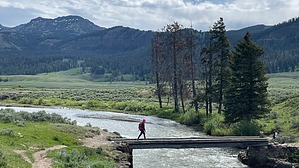
Move over, Bison!! by Vashti This is a meadow hike filled with herds of Bison. If you don't like 3000 lb animals literally sitting on the trail that you then have to detour around, then this is NOT the hike for you. There were Bison EVERYWHERE. SO MANY BISON!! Hike This hike starts at the Lamar River Trailhead, which is right off the Yellowstone Northeast Entrance Road. There is also another trailhead that leads to this trail, which is the Lamar River Stock Trailhead, which is also right off the main road, shortly before the pedestrian Trailhead.
The trail starts from the lot and immediately goes down to the river for a crossing via a wooden bridge. Once across, the trail heads off to the right and into a meadow full of Bison. Bison everywhere, several of which were lying down right on the trail. It is possible to detour around them and then come back to the trail once you are a safe distance away. This meadow is right next to Soda Butte Creek, and the trail parallels the creek for a time. After a short while, the trail heads up a short rise right next to where the creek turns away from the trail. On our visit, there was also a massive herd of Bison in this area, some of which were on the trail. After making a detour to get up the rise, we made our way away from the herd into a meadow with scrub and not much else. Being there midday was a bit brutal in the hot sun. This hike is best done earlier in the morning when it is cooler! Continuing, the Lamar River Trail is joined by the trail heading in from the other (stock) trailhead. The junction is signed. More meadow (but to be fair, a Meadow in beautiful surroundings! Gorgeous views of nearby hills and mountains) until the next junction, which is signed. The Lamar River Trail bears left and slightly uphill. The Specimen Ridge Trail continues straight towards the Lamar River for a river crossing before heading up Specimen Ridge. I find it interesting that the Lamar River Trail is not really near the Lamar River. ? You can see it in the distance, but it is not close by. You don't get a good look at it. At least not for the first few miles until the junction with the Cache Creek Trail, which is the turnaround point for this Guide. After the junction with the Cache Creek trail, the Lamar River Trail crosses Cache Creek and then along the Lamar River for many, many miles. There are 14 backcountry campsites (permit required) along the river/trail past the Cache Creek crossing. One other note about the Specimen Creek trail: Due to high water levels during spring runoff, the Trail is closed from May to July at the Lamar River, as it is not possible to cross the river with high water levels. But I digress. Back to the junction with Specimen Creek Trail at 1.4 miles from the pedestrian trailhead. Bear left and uphill to continue on the Lamar River trail. While climbing slightly uphill, this meadow is where we encountered another huge Bison herd. They were maybe 30ish feet away from the trail on the riverside of the trail. Also interspersed with the Bison were some Pronghorn. After passing the herd by, it is smooth sailing continuing through the meadow and enjoying the wild flowers. Nothing too exciting, and at 3.1 miles, the signed junction with the Cache Creek Trail is reached. This was our turnaround point, so we had a bit of lunch before returning the way we came. Check out the Official Route and Triplog. Leave No Trace and +Add a Triplog after your hike to support this local community. One-Way Notice This hike is listed as One-Way. When hiking several trails on a single "hike", log it with a generic name that describes the hike. Then link the trails traveled, check out the example. | ||||||||||||||||||||||||||||||||||||||||||||||||||||||||||||||||||||||||||||||||||||||


