Overview Schafer Peak sits at the west end of Green Monarch Ridge above Lake Pend Oreille. The start of the trail can be reached via either Green Monarch Trail #69 or Tepee Gulch Trail #105.
Hike Schafer Peak Trail #68 starts at the saddle between Schafer Peak and Green Monarch Mountain, which is also the junction of Trails 68, 69, and 105, although it is not signed. From the junction, the trail heads west and uphill. The trail does not seem to receive as much maintenance as the other trails in the area, and is a little more overgrown. The climb is fairly steady, and due to less dirt biking on this trail, the trail surface is in good shape. Pushing through the vegetation and over occasional deadfall is the biggest challenge.
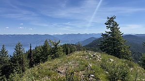
After about half a mile, the trail starts to follow an old road bed for a short distance, on the south side of the ridge. There are some great views of Packsaddle Mountain to the south from this section. The roadbed only lasts about a quarter mile before the trail shifts back to the ridge. Getting closer to the summit, the trail crosses a talus slope. Once reaching the summit, there are the remains of an old lookout tower, although not much is left beyond the old concrete footers, a few pieces of lumber, and a pile of rusty nails. The summit has some good views of the lake and plenty of places to sit on the rocks.
When hiking several trails on a single "hike", log it with a generic name that describes the hike. Then link the trails traveled, check out the example.
WARNING! Hiking and outdoor related sports can be dangerous. Be responsible and prepare for the trip. Study the area you are entering and plan accordingly. Dress for the current and unexpected weather changes. Take plenty of water. Never go alone. Make an itinerary with your plan(s), route(s), destination(s) and expected return time. Give your itinerary to trusted family and/or friends.
 Route Editor


