Overview Tepee Gulch Trail is a short, steep trail up to Green Monarch Ridge. It is the shortest way to reach the summits of both Schafer Peak and Green Monarch Peak. The trail is popular with dirt bikers.
Hike Tepee Gulch Trail starts on the north side of FS-1063. There is a small sign at the start of the trail. Immediately at the start of the trail, there is a small creek flowing, but it is easy to step over. After that, the steep climb begins as the trail switchbacks uphill. Most of the straight portions of the trail are in good condition, but nearly every corner is torn up from the dirtbikes, and some are difficult to negotiate. If dry, you can get up each corner pretty much upright, but if the trail is wet, you will be sliding.
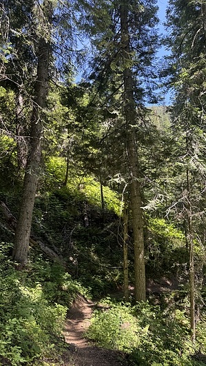
Other than the eroded corners, it's a fairly nice hike uphill through the trees. Most of the views are behind you if you are going uphill. Once at the top of the trail, you will be at the junction with the trails that lead to either Schafer Peak (west) or Green Monarch Mountain (east). There's really no reason to hike Tepee Gulch Trail unless you are planning on heading to at least one of these summits. Either one is about a mile away from the junction at the top of the trail.
When hiking several trails on a single "hike", log it with a generic name that describes the hike. Then link the trails traveled, check out the example.
WARNING! Hiking and outdoor related sports can be dangerous. Be responsible and prepare for the trip. Study the area you are entering and plan accordingly. Dress for the current and unexpected weather changes. Take plenty of water. Never go alone. Make an itinerary with your plan(s), route(s), destination(s) and expected return time. Give your itinerary to trusted family and/or friends.
Permit $$
FS
Directions
Road
FR / Jeep Road - Car possible when dry
To hike From I-90 in Coeur d'Alene, take US-95 north approximately 45 miles to Sandpoint. In Sandpoint, take Hwy 200 east approximately 25 mi to the small town of Clark Fork. In Clark Fork, turn right on Stephen St and go south approximately 0.30 mi, cross the railroad tracks, and turn left on River Rd. Take River Rd approximately 0.70 miles and cross the bridge. Once over the bridge, take an immediate sharp right onto Johnson Creek Rd (aka Natl Forest Development Rd 1080, aka FS-278) and go approx 9.50 mi up to Johnson Saddle. At the saddle, turn right to stay on Forest Development 1080/FS 278 and take it another 5 mi to FS-1063 at the corner of a hairpin turn. There is a sign for trails 105 & 68 at this turn. Take FS-1063 approximately 0.50 mi to the start of Trail 105, which is at a turn in the road. There is room to park at the side of the road at this turn. The trail is on the north side of the road.
 Route Editor


