Route Editor

| Guide | ♦ | 5 Triplogs | 0 Topics |
details | drive | no permit | forecast | map |
stats |
photos | triplogs | topics | location |
| 5 | 5 | 0 |
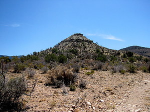
Why Go!? by imike If it happens to be a colder, wintry day and you desire a fully sunexposed ridge hike with no challenge in regards to route finding... then, perhaps that is the right hike for such a day. It does offer nice perspective views of the two adjacent canyons on either side, and for a touch of variety and additional challenges, there are three ridge peaks just off the road that can add a touch of adventure and extra workout. The tallest of these, Stark Peak, rises to 7340', depending on the route off trail chosen, might add 400-600' of additional climbing to the hike. The lower prominent point stands at 6120'... this unnamed high point affords great 360 degree views down on the far west end of the ridge, just before the trail begins it's final drop to the edge of the mesa. The third point lies between the two... might as well hit it as well and turn the day into a mini-peak bagging session.
That is not to say you cannot make it down... you can, I did. I chose to take the first drainage around on the north side back from the point of the ridge. This was a rock lined cataract, that if it was not for all the over grown shrubs and trees obscuring the way, I would have classified as the most fun part of the hike. But, of course, it is not part of the hike; Aquaduct Ridge trail/road ended up on top. You could also likely simply follow the pipeline itself down the side.. it looks doable. So... the trail is there... the little peaks are there... the cold pipeline is there. If you have to, go check it out. From the trailhead up on Westside road you will be following the path common to trail #104 for the first 2 miles. T104 turns off the roadway to the left at that point, you continue straight and on up the hill. Check out the Triplogs. Leave No Trace and +Add a Triplog after your hike to support this local community. | ||||||||||||||||||||||||||||||||||||||||||||||||||||||||||||||||||||||||||||||||||||||||||