 Route Editor

| Guide | ♦ | 1 Triplog | 0 Topics |
details | drive | no permit | forecast | 🔥 route |
stats |
photos | triplog | topics | location |
| 17 | 1 | 0 |
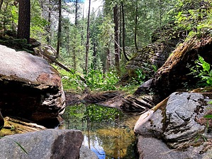
Dodge and Jump. No Run. by kingsnake   Sandstone Canyon is a short canyon that begins at Sandstone Tank and ends just 2¼ miles later at West Leonard Canyon. It is dead center on Rim Road, just a mile west of Knoll Lake. Sandstone Canyon is a short canyon that begins at Sandstone Tank and ends just 2¼ miles later at West Leonard Canyon. It is dead center on Rim Road, just a mile west of Knoll Lake.From the trailhead, head west across FR 295. The tank is in 75 yds. From there, follow the low line, off the north side of the tank. The first ¾ mile is easy going. The next 1½ miles are rocky with steady deadfall. Nothing too tangled, or dangerous, but it's constant up & over, or down & under. There are no shelves to speed your way for a hundred or two yards. However, it is mostly shady.
At 1½ miles, there is a bail point, right & up to FR 9743A. Where Sandstone meets West Leonard, there's a bit of shelf to sit on. At least that part of West Leonard looks like it has a fair amount of tangly vegetation. If you continue down West Leonard, it is ~3 miles to the junction with East Leonard Canyon, and it's relatively easy bail to FR 295. Check out the Official Route and Triplog. Leave No Trace and +Add a Triplog after your hike to support this local community. One-Way Notice This hike is listed as One-Way. When hiking several trails on a single "hike", log it with a generic name that describes the hike. Then link the trails traveled, check out the example. | ||||||||||||||||||||||||||||||||||||||||||||||||||||||||||||||||||||||||||||||||||||||||||||||


