Overview Packsaddle Mountain is a scenic peak in the Coeur d'Alene Mountains of North Idaho. The long drive to the trailhead on forest roads limits the number of visitors to this peak, but it is well worth the effort.
Hike While there are a couple of trails that lead to the summit of Packsaddle Mtn, the approach from the eastern end of Trail #76 is the shortest route. The trail starts on the northeast side of the parking area, and initially follows an old road for maybe 100'. There is a brown trail sign where the trail veers left and uphill. The next two miles are a steady uphill climb on a rough trail surface--lots of rocks and roots--but overall, the trail conditions aren't too bad. The trail is easy to follow as it climbs through the dense vegetation. In July & August, huckleberries are abundant along nearly the entire trail.
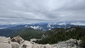
In the first mile, you'll pass a couple of large boulder fields, but the trail skirts along the edge of them as it switchbacks uphill. Nearing the summit, the trees thin, and there are some incredible views. The switchbacks also end as you wrap around the east side of the summit and head. More talus fields appear, and as you reach the summit, there is a large pile of talus ahead of you and slightly to the right. The trail leads to the base of the rocks, and a surprisingly stable path winds through them up to the summit. It is a very mild scramble. The remains of an old lookout are scattered about. Excellent views in all directions, with Lake Pend Oreille to the west and north, and the Coeur d'Alene Mountains to the east and south.
Once done, you can retrace your steps steeply back downhill, which seems a lot more slippery than the ascent felt.
WARNING! Hiking and outdoor related sports can be dangerous. Be responsible and prepare for the trip. Study the area you are entering and plan accordingly. Dress for the current and unexpected weather changes. Take plenty of water. Never go alone. Make an itinerary with your plan(s), route(s), destination(s) and expected return time. Give your itinerary to trusted family and/or friends.
Permit $$
FS
Directions
Road
High Clearance possible when dry
To hike Medium clearance recommended, no need for 4WD if snow-free.
From Coeur d'Alene, take US-95 north for approx 15 miles to Bunco Rd. Turn right and take Bunco Rd (aka FS-332) east for approx 31.5 miles to a saddle. At the saddle, make a very sharp left. It is marked at FS-1073 on some topo maps, and there is a sign at the turn marking trails 76 & 111. Take FS-1073 west for 1.8 mi to the parking area for both trails. There is room for about 6-8 vehicles to park.
If coming from Sandpoint or areas north of Lake Pend Oreille, take Hwy 200 east to the town of Clark Fork. Turn right on Stephens, cross the railroad tracks, and turn left on River Rd. Cross the bridge over the river, then turn right on Johnson Creek Rd (aka FS-1080, or FS-278). Take Johnson Creek Rd/1080/278 for 9.5 miles up to Johnson Saddle. Stay left (straight) onto FS-1066 and stay on FS-1066 for 3.50 miles to ANOTHER Johnson Saddle. At this saddle, turn right onto FS-332. Take FS-332 for 4 miles to a saddle and stay right onto FS-1073, which will be marked with a sign for Trail 76 & 111. Take FS-1073 west for 1.8 mi to the trailhead.
 Route Editor