 Route Editor

| Guide | ♦ | 1 Triplog | 0 Topics |
details | drive | permit | forecast | route |
stats |
photos | triplog | topics | location |
| 39 | 1 | 0 |
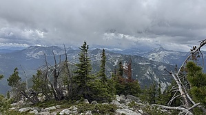
Bueller Spin-off by LindaAnn Hike On the south side of Parker Peak, along Parker Ridge Tr#221, there is a signed spur trail to the summit of Parker Peak. Head north on this spur trail as it steadily climbs the south slope of Parker Peak. The trail switchbacks uphill, before finally following the south ridge to the summit. The west side of the ridge has some trees, and the east side of the ridge is a talus slope--the trail follows that dividing line almost perfectly.
The only other peak in the area that is higher than Parker Peak is the Boundary County Highpoint, an unnamed peak (either 7709 or 7714, it seems to vary) on the ridge a few miles to the south of you, and is about 50' higher. Note Reaching Parker Peak Trail involves hiking in on Parker Ridge Trail from either the east or south. Coming in from the east is at least 10 miles with over 5000' elevation gain, making for a 20+ mile round trip; or coming in from the south via Pyramid Pass, which is 8 miles and over 3000' elevation gain, making for 16+ miles round trip, with 4800' elevation gain. Check out the Official Route and Triplog. Leave No Trace and +Add a Triplog after your hike to support this local community. One-Way Notice This hike is listed as One-Way. When hiking several trails on a single "hike", log it with a generic name that describes the hike. Then link the trails traveled, check out the example. | |||||||||||||||||||||||||||||||||||||||||||||||||||||||||||||||||||||||||||||||||||||


