Route Editor

| Guide | ♦ | 4 Triplogs | 0 Topics |
details | drive | permit | forecast | route |
stats |
photos | triplogs | topics | location |
| 22 | 4 | 0 |
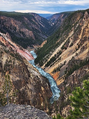
Backcountry Thermal Goodness! by Vashti This hike encompasses views of the Grand Canyon of the Yellowstone along with an off-the-beaten-path Thermal area. Hike The hike starts at the upper falls viewpoint parking lot, which also serves as parking for the Clear Lake trailhead. The loop can be done in either direction, but the description is for clockwise. Start at the lookouts on the east side of the parking lot. There are plenty of great lookouts here of the falls. The canyon itself is not super wide, so it is interesting that you can see all the people gathered at various viewpoints and on the trail across the canyon on the north rim.
But back to the start... shortly after starting along the canyon, there is a dilapidated trail heading down into the canyon. It is blocked off by the park service with cones. This is the junction with the now-closed Uncle Tom's Stairs Trail. This trail is mainly metal stairs that go steeply down into the canyon for a lookout viewpoint. Sadly, they have been closed for a number of years now. There is some early history surrounding this trail, as the creator was the operator of the ferry across the river before the bridge was up. He also took people on tours in the area. He would take them to the canyon using a series of ropes and ladders. When the National Park Service took over the area, they put up the metal stairs instead. They provided many years of service, but now are in need of repair. The price tag to renovate was so high that the nps closed the trail. Sad day! You can still see the steep metal stairs looking at the south rim from the north rim. Craziness! From the crowds at the upper falls viewpoint parking lot, continue along the south rim trail and enjoy the many views of the canyon along the way. The trail is mainly open to the canyon (and oftentimes near the edge of it) until the artist viewpoint, where you are back in the crowds. Take a few minutes to enjoy the stunning views of the multicolored rocks before continuing. Follow the ribbon lake trail sign towards Point Sublime. 10 steps away from the artist point lookout, and you are in solitude again. Glorious! The canyon views continue until the junction with the Clear Lake Trail. Bear right at the junction, away from the canyon and into the forest. After a short distance and time, you come upon Lily Pad Lake on your right. You don't get a super clear view of it, as it is surrounded by trees. There are a few short use trails to its shore. As its name implies, there are lily pads. :) It is a clear lake with a lot of dead trees and also some air bubble features signifying thermal activity. After a gander, continue on alongside the small lake for a distance until the lake ends and a trail junction is encountered. Ribbon Lake is to the left, but this trip heads to the right towards Clear Lake. The forest thins out, and the backcountry thermal area begins! The first feature encountered is a large bubbling mud pool giving off a large steam plume. The feature is just off the trail. Follow a wide spur trail off to the left that takes you right up to the feature. It is very impressive, bubbling, gurgling, and steaming away. And the best part... NO PEOPLE!! NONE! AMAZINGNESS! After oohhing and ahhing at the feature, return to the main trail and continue. Right away, you enter a considerable thermal area with many features. And still no people! It is so nice to observe a thermal area without hordes of people everywhere. There are all types of features to see. After looking your fill at the steaming and bubbling pools and fumaroles, you come upon Clear Lake, which itself has bubbling features within it. Clear Lake is very clear and greenish blue. The width of the lake nearest the trail is free of trees, providing a great view of the lake. After heading away from Clear Lake, the thermal area is left behind, and the trail continues into a meadow area. There are trees around (many with bark stripped from their trunks thanks to bears; this is a bear area), but it is mainly grassy meadows. The trail is easy to follow. Not too far from Clear Lake is a junction, bear right to take the Clear Lake Trail back to the Clear Lake trailhead and overlook parking area. After a while, the trail is parallel to the south rim road. Eventually, you cross the road to head back to the trailhead. If a longer hike is desired, instead of starting the loop at the Clear Lake trailhead, the loop can be started at the Wapiti trailhead, which is just after the bridge over the Yellowstone River on the right side. Most of the hike is the same, but there is additional trail mileage right next to the Yellowstone River at the start, before the lower falls overlook/clear lake trail head parking lot is reached. To return to the Wapiti trailhead, bear left at the junction just past Clear Lake for more hiking through meadows. Note No permit is necessary to day hike in the area, but backcountry permits are required to backpack and camp. All campsites are designated and must be reserved. Synopsis This hike has a lot to offer, with a backcountry thermal area, the magnificent views along the south rim of the Yellowstone Grand Canyon, grassy meadows, and scenic lakes. And once you leave the populated rim parking lot areas, you have the trail to yourself! Check out the Official Route and Triplogs. Leave No Trace and +Add a Triplog after your hike to support this local community. | ||||||||||||||||||||||||||||||||||||||||||||||||||||||||||||||||||||||||||||||||||||||