 Route Editor

| Guide | ♦ | 1 Triplog | 0 Topics |
details | drive | no permit | forecast | map |
stats |
photos | triplog | topics | location |
| 4 | 1 | 0 |
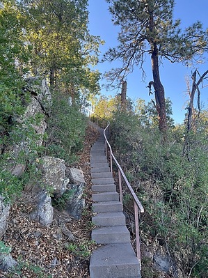
 Overview OverviewThe Blue Vista Trail #347 is a brushy quarter-mile trail that begins at the Blue Vista Viewpoint and continues south along a ridgeline to an unnamed summit for some expansive views of the southern Blue Range and beyond. The ridgeline has been taken over by your usual assortment of post-fire pioneer species since the most recent fire, and as a result, views have been greatly diminished, and the trail is prone to growing over. The trail begins at the top of a stairwell south of the restrooms and parking area at the Blue Vista Viewpoint. Check out the Triplog. Leave No Trace and +Add a Triplog after your hike to support this local community. One-Way Notice This hike is listed as One-Way. When hiking several trails on a single "hike", log it with a generic name that describes the hike. Then link the trails traveled, check out the example. | ||||||||||||||||||||||||||||||||||||||||||||||||||||


