Route Editor

| Guide | ♦ | 1 Triplog | 0 Topics |
details | drive | no permit | forecast | route |
stats |
photos | triplog | topics | location |
| 10 | 1 | 0 |
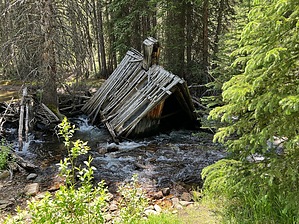
Keep Cool with Coolidge by FOTG The abandoned Coolidge Townsite is located within the Beaverhead-Deer National Forest and is accessed from the Pioneer Mountain Scenic Byway. An old road now serves as the trail to view the old mining town, which can be seen almost entirely through a leisurely one-mile walk each way. History The community of Coolidge was comprised mainly of miners who worked at the Elkhorn Mine and Mill and their families. The community was established in 1914 and was named after the U.S. President who was a friend of one of the early claim holders. At its height, the population of Coolidge reached approximately 350 people, plus perhaps an additional 100 men who lived and worked at another mine nearby. The town gained a post office in 1922 and a school in 1918. There was electricity and a telephone service; however, indoor plumbing was rare. Harsh winters, falling silver prices, and the remoteness of the area took their toll on the community. By 1932, most of the people had left Coolidge, and the post office closed. Coolidge never had a saloon and never built a Church.
From the trailhead parking area, walk southeast to reach the abandoned road that takes you to Coolidge. The old provides an excellent walking surface, and the walking is pleasant. The old road will take you through a short section of forest before reaching the townsite. You may cross a couple of trickling streams of water as you near the townsite, which also marks where some nice creek side walking begins as well. Once you have arrived at the site, explore responsibly within your content. A one-mile hike in is suggested at the trailhead and makes for an ideal turnaround point. However, there is much to explore in the area for those who are comfortable and capable of exploring beyond the townsite. Check out the Official Route and Triplog. Leave No Trace and +Add a Triplog after your hike to support this local community. | ||||||||||||||||||||||||||||||||||||||||||||||||||||||||||||||||||||||||||||||||||||||||||||