Route Editor

| Guide | ♦ | 8 Triplogs | 0 Topics |
details | drive | no permit | forecast | route |
stats |
photos | triplogs | topics | location |
| 19 | 8 | 0 |
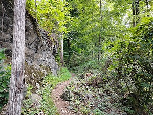
George Washington hiked here! by Jim  Numerous trails exist within the park, and the summit trail is one of two trails easily accessed from NJ 29. The Summit Trail appears to be the most popular way to access the park, and has a large parking lot at the trailhead. You will probably have company for the hike, but if it's hot or unpleasant, you can find solitude.
Just before the 1/2 mile point, the trail splits. This is a little confusing, but both trails are marked with the blue squares and are considered the same trail. The right fork appears to be less popular, and takes you to the Ridge Trail, where it is paved just east of Strawberry Hill. The more popular main trail to the left leads to the summit at the top of the meadow. Taking the main trail to the left, at the 3/4 mile mark, a gravel road is met. Take another left here, and then after a short distance, a right towards the meadow. Past this point, the trail is not marked, from what I saw. The trail turns slightly to the right and uphill as you enter the meadow area. Following the mowed path will lead to the top of the hill and the Ridge Trail, where there is a collection of picnic tables and a set of public binoculars on a post. You can see Philadelphia on a good day, reportedly. At the top, you can explore more of the meadow, some of the other trails, or simply return to your car at the parking lot. You can also make a loop using the less-traveled right fork of the trail out near Strawberry Hill. Poison Ivy is very common here. I found it in the grass where it was mowed, and in the herbaceous plants growing along the trail. It's also common in the rocky section around the steps. You'll want to watch for the poison ivy, and you may not want to hike this in the green months. It's common all over the western edge of the park, with huge 3 to 4-inch vines growing in the old trees. Sometimes these vines fall from the trees onto the paths.
Check out the Official Route and Triplogs. Leave No Trace and +Add a Triplog after your hike to support this local community. | |||||||||||||||||||||||||||||||||||||||||||||||||||||||||||||||||||||||||||||||||||||