Route Editor

| Guide | ♦ | 9 Triplogs | 0 Topics |
details | drive | no permit | forecast | route |
stats |
photos | triplogs | topics | location |
| 31 | 9 | 0 |
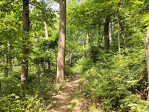
A single switchback! by Jim  Just off NJ 29, the Switchback or Yellow Trail is one of the popular access trails, though it seems to be less popular than the nearby Summit Trail, possibly due to limited parking. It does offer more elevation gain than the Summit Trail and is shorter overall. A large meadow area near the western high point has scenic views and makes for an excellent destination hike.
The trail terminates officially at the red trail junction and is close to the white Ridge Trail. To reach the summit vista, turn right onto the red trail and shortly after turn left onto the Ridge Trail. This will take you to the vista area at the top of the meadow, where there are picnic tables and a public binocular on a post. There are additional tables under a honey locust just down slope from the vista area. At the top, you can explore the meadow and additional trails, or return to your vehicle descending the way you came. Poison ivy is plentiful in the park. This trail had a lot of large vines in the trees, and when they fall down onto the trail, a risk is posed if you encounter them. However, the only poison ivy I noticed growing discreetly along the trail was in the area of the mowed trail at the very beginning, and was easy to avoid. The county appears to cut this section regularly, and it grows in from the adjacent meadow at the beginning, but it should not be a problem. This trail has far less poison ivy than the Summit Trail.
Check out the Official Route and Triplogs. Leave No Trace and +Add a Triplog after your hike to support this local community. | |||||||||||||||||||||||||||||||||||||||||||||||||||||||||||||||||||||||||||||||||||||