Route Editor

| Guide | ♦ | 1 Triplog | 0 Topics |
details | drive | permit | forecast | route |
stats |
photos | triplog | topics | location |
| 0 | 1 | 0 |
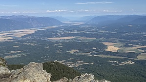
come for the views & stay aware by LindaAnn Hike: The trail begins on the south side of the parking area, and is marked with a large brown bulletin board. Clifty Mountain Trail #182 heads east from here, which you will utilize for the start of the hike. The uphill begins immediately, as you hike through the forest. Views are initially limited by trees. The trail surface is mostly in good shape, with some exposed tree roots.
After enjoying the views, retrace your steps back downhill. Black Mountain, immediately to the west, must have a cell tower located at the electronics site at the summit, because cell service is surprisingly good along this hike. Note: Bears, both black and grizzly, frequent this area. Remain aware of your surroundings. Check out the Official Route and Triplog. Leave No Trace and +Add a Triplog after your hike to support this local community. | |||||||||||||||||||||||||||||||||||||||||||||||||||||||||||||||||||||||||||||||||||||