Route Editor

| Guide | ♦ | 1 Triplog | 0 Topics |
details | drive | permit | forecast | route |
stats |
photos | triplog | topics | location |
| 0 | 1 | 0 |
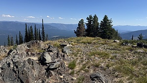
Coast to Katka by LindaAnn Hike: Clifty Mountain Trail #182 starts from the south end of the parking area and heads east from the road. It is marked by a large brown bulletin board. The trail heads uphill through the dense forest. At 1.20 miles, the trail forks. The left fork is a spur to the summit of Clifty Mountain, which is worth the extra 1.60 miles it adds to the hike, and the right fork is the continuation of the main trail. At this fork, the trail narrows slightly, but is still in good shape and easy to follow.
After that, the trail climbs again along the slopes of 6307 and 6373, then drops again to the next saddle. The roller coaster continues as you head generally east towards Katka Pass. Most of the time, the best views are to the south and east, but you get a few spots with views to the north. The trail is rocky in places, usually in the steeper spots. Shortly before reaching Katka Pass, you'll reach the junction with Trail #143. Mileage signs at this junction are a little suspect. Stay left at the junction. After that, you can start to see Katka Peak high above you to the right. The slopes look impossibly steep. Because they are from this side. At Katka Pass, the trail turns right and traverses the south slope of Katka. At the southeast end of Katka, there is another signed junction; turn left to take the spur up Katka, now leaving Trail #182. Again, the mileage signs at this junction are not particularly accurate--don't get your hopes up. Now heading up the spur trail to Katka, the first 1/3 mile is in good condition and climbs about 200'. Suddenly, the trail will end. There are the remnants of an old fire tower just above you to your right, but this is not the summit. At the end of the trail, make a left and work your way west and uphill. Occasionally, you will see hints of an old path, but it is nearly impossible to discern in places. Fire, erosion, and lack of use have taken over. Luckily, the off-trail is not particularly difficult, and if you pay attention, you can probably find hints of the path in places. The off-trail is about half a mile, gaining about 200', so it's not too bad. Katka Peak burned in recent years, and the trees immediately around the summit are mostly dead. On the bright side, this gives you some decent views. Retrace your steps as best you can back downhill as you head towards where the trail begins again. Then enjoy the six-mile roller coaster back to the trailhead. Note: Bears, black and grizzly, can be found in this area--remain aware. Carry all the water you need on this hike. There is supposedly a spring along the trail on the south slope of Katka Peak, but it was dry in Aug 2025. No other potential water sources. Check out the Official Route and Triplog. Leave No Trace and +Add a Triplog after your hike to support this local community. | |||||||||||||||||||||||||||||||||||||||||||||||||||||||||||||||||||||||||||||||||||||