Route Editor

| Guide | ♦ | 2 Triplogs | 0 Topics |
details | drive | no permit | forecast | route |
stats |
photos | triplogs | topics | location |
| 0 | 2 | 0 |
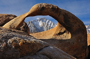
Go red in the blue state by John10s  The Alabama Hills are located on the east side of the Sierra Nevada range near Lone Pine, CA and are known for their scenic rock piles and natural arches, along with spectacular views of the peaks of the Sierras, including Mt. Whitney and Lone Pine Peak. Although the rounded, darker boulders common in the Alabama Hills contrast sharply with the lighter, jagged peaks of the Sierras, they are formed from the same type of rock, but different weathering patterns led to extreme differences in appearance. The Alabama Hills are a popular spot for dispersed camping, photography, and stargazing. Arch Loop Trail is a short, easy loop hike covering roughly two-thirds of a mile that passes some of the most popular and well-known arches in Alabama Hills, including Mobius Arch. With an elevation of ~4,600', temperatures get hot in the summer, so the other seasons are a more ideal time to visit, and the landscape is particularly dramatic with more snow in the Sierras.
The Alabama Hills were named after a Civil War-era Confederate warship called the CSS Alabama, which gained a following among pro-Confederate miners in the area. They named multiple mining claims after the ship, and the Alabama name eventually stuck for the whole area. Starting in 1969, the BLM managed Alabama Hills as a recreation area, and five decades later, in 2019, Congress re-designated the area as a national scenic area. Since the 1920s, hundreds of movies and TV series have been filmed in the Alabama Hills, including many mid-century Westerns as well as more recent movies, such as Iron Man. The nearby Lone Pine Film History Museum documents the long history of filming in the area. Hike Arch Loop Trail is one of a limited number of official, signed trails in Alabama Hills, and the trailhead has a large dirt parking lot and portable bathrooms across the road. From the parking lot, Heart Arch is visible to the northeast; this is actually one of the better angles to view the heart-shaped opening in the rock. Starting clockwise from the parking lot, the trail dips slightly, and you'll soon pass a signed intersection where Alabama Hills Trail branches off to the north. Just under a quarter mile into the loop, Lathe Arch appears on the south side of the trail--a long, narrow opening low to the ground. Just ahead on the same side of the trail is Mobius Arch, one of the most popular and most photographed features in Alabama Hills. This arch is named for its resemblance to a Möbius strip, an object with a one-sided, one-edged two-dimensional shape (picture a twisted strip of paper with the ends joined to form a loop). This is a popular spot for photos of the Sierra peaks framed through the arch. Continuing clockwise, around four-tenths of a mile into the loop, you'll pass another signed intersection for Alabama Hills Trail, and just beyond it is Heart Arch, which is less impressive from this angle. Finishing off the loop, the trail passes multiple smaller, unnamed holes and arches in the rock formations close to the ground. Although Arch Loop is the most popular hike in the Alabama Hills, there are many other interesting features to check out in the vicinity, including Cyclops and Boot Arches, the Eye of Alabama Hills, Gene Autry Rock, and more. All of these are accessible via short, easy hikes off Movie Flat Road, so consider visiting some of these less popular locations. Check out the Official Route and Triplogs. Leave No Trace and +Add a Triplog after your hike to support this local community. | ||||||||||||||||||||||||||||||||||||||||||||||||||||||||||||||||||||||||||||||