username
X
password
register
for free!
help
 This is likely a great time to hike this trail!  Check out "Preferred" months below, keep in mind this is an estimate. 
  

Baldpate Mountain via the Appalachian Trail, ME

Guide 1 Triplog  0 Topics
  5 of 5  
Fav
Wish
0
details
drive
permit
forecast
route  
stats
photos
triplog
topics
location
15 1 0
Statistics
tap row or icons for details
Difficulty 3 of 5
Route Finding 2 of 5
Distance Round Trip 7.7 miles
Trailhead Elevation 1,496 feet
Elevation Gain 2,296 feet
Accumulated Gain 2,990 feet
Avg Time Round Trip 5 hours
Kokopelli Seeds 22.65
 Interest Seasonal Creek, Perennial Creek & Peak
 Backpack Yes
feature photo
Photos Viewed All MineFollowing
Inaugural Calculation on Button Tap!
15  2025-09-12 Jim
Author
author avatar Guides 75
Routes 189
Photos 10,231
Trips 2,335 map ( 14,229 miles )
Age 46 Male Gender
Location
Historical Weather
Trailhead Forecast
Radar Map
Expand Map
Preferred Aug, Sep, Oct, Nov → 9 AM
Seasons   Late Spring to Late Autumn
Sun  6:08am - 4:48pm
Official Route & 1 Rt
 
0 Alternative


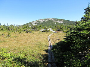
Less than 4,000' but has the views!
by Jim

 Likely In-Season! 
Expand MapBaldpate Mountain, also known as East Baldpate due to there being a lower western summit, in northwest Maine, is one of the more scenic summits found along the Maine section of the Appalachian Trail. It is moderately popular as a day hike, along with the much more popular Old Speck, which is across Maine Route 26, and so in good weather, this summit is likely to have a fair number of fellow hikers. However, because this is not over 4,000 feet high, it does not attract list hikers who come to hike Old Speck, despite the forested summit on that mountain.


Ranked #28 in prominence for the New England 50 Finest peakbagging list, it has 2,240' of prominence, and a summit elevation of 3,815 feet. Views at the summit are expansive, and the summit is mostly bare thanks to the last ice age scraping off the top. Old Speck, on the other hand, is mostly forested and has a tower for views. I know I'll take a lower summit with views, any day!
remove free decal offer
The hike leaves from the Grafton Notch (pass) Trailhead and heads north on the Appalachian Trail. You'll be hiking for over 3.5 miles in dense Maine forest, ranging from maple and birch to red spruce as you gain elevation, and finally high elevation (for the region) balsam fir. Numerous creek crossings exist, along with several sections of log bridges and boardwalks, carefully constructed rock steps, and one wooden ladder to descend West Baldpate.

Views begin to open up as you descend West Baldpate. They become expansive and much more enjoyable as you start to ascend the friction slabs and ledges leading to the summit of Baldpate proper, or East Baldpate. I thought this area had a Sierra Nevada feel to it, although not as massive.

The true summit has incredible views of nearby mountains and forest. Beyond Old Speck, Mount Washington is visible in New Hampshire, and plenty of nearby Maine mountains, too.

This summit is located at the junction of the Appalachian Trail and the Grafton Notch Loop, so you can continue on either trail for however long you desire if backpacking. If not, return to your car the way you came.

Hazards: A deep snowpack is reported to exist in most winters, with spring melt-off producing heavy stream flow, which could complicate water crossings. Early summer in Maine is black fly season. It might be best to avoid unless prepared to deal with them. I do not know how common they are here or around the mountain. Mosquitoes are probably common, but with less surface water in dry years, they will be encountered less often. I had none, due to a drought. Late summer and fall are probably the best times to hike this mountain.

Lodging can be found in nearby small towns, and a private campground is a few miles south of the park.

2025-09-16 Jim


    Check out the Official Route and Triplog.
    Leave No Trace and +Add a Triplog after your hike to support this local community.
    WARNING! Hiking and outdoor related sports can be dangerous. Be responsible and prepare for the trip. Study the area you are entering and plan accordingly. Dress for the current and unexpected weather changes. Take plenty of water. Never go alone. Make an itinerary with your plan(s), route(s), destination(s) and expected return time. Give your itinerary to trusted family and/or friends.

     Permit $$
    Special Use

    Special
    To be determined...


     Directions
    or
     Road
    Paved - Car Okay

    To hike
    Take I-95 north from Portland Maine, to exit 63. After exiting I-95, proceed west on US 202 over the interstate and turn right, or north onto Maine Route 26. Continue north on ME 26 for 68.8 miles to Grafton Notch State Park and the trailhead, which is on the west side of ME 26. The trailhead turnoff is marked with a wooden sign reading "Hiking Trails". There is a sign indicating the trailhead is ahead 1500 feet before the turn. Maine 26 shares an alignment with other numbered roads at times. A small honor system fee is charged at the trailhead.
    page created by Jim on Sep 16 2025 11:23 am
    helpcorrectionissue

    end of page marker