username
X
password
register
for free!
help
  This is likely a great time to hike this trail!  Check out "Preferred" months below, keep in mind this is an estimate. 
 

Buzzard Peak, CA

Guide 1 Triplog  0 Topics
  0 of 5  
Fav
Wish
0
details
drive
no permit
forecast
route  
stats
photos
triplog
topics
location
16 1 0
Statistics
tap row or icons for details
Distance Round Trip 3.15 miles
Trailhead Elevation 754 feet
Elevation Gain 632 feet
Accumulated Gain 852 feet
Kokopelli Seeds 7.41
 Interest Peak
feature photo
Photos Viewed All MineFollowing
Inaugural Calculation on Button Tap!
16  2025-09-10 PatrickL
Author
author avatar Guides 595
Routes 0
Photos 0
Trips 247 map ( 429 miles )
Age ?
Location
Historical Weather
Trailhead Forecast
Radar Map
Expand Map
Preferred Dec, Jan, Feb, Mar
Sun  6:41am - 4:42pm
Official Route
 
0 Alternative


remove free decal offer

  Likely In-Season! 
Expand MapHighpoint of San Jose Hills at 1,375ft

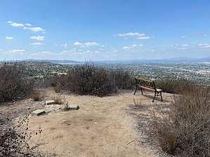
Official route begins at Grand Ave, utilizing Schabarum Skyline Trail. Nearby parking available in neighborhood west of trailhead.


    Check out the Official Route and Triplog.
    Leave No Trace and +Add a Triplog after your hike to support this local community.
    WARNING! Hiking and outdoor related sports can be dangerous. Be responsible and prepare for the trip. Study the area you are entering and plan accordingly. Dress for the current and unexpected weather changes. Take plenty of water. Never go alone. Make an itinerary with your plan(s), route(s), destination(s) and expected return time. Give your itinerary to trusted family and/or friends.

     Permit $$
    None


     Directions
    or
     Road
    Paved - Car Okay

    To hike
    page created by PatrickL on Sep 10 2025 2:56 pm
    helpcorrectionissue

    end of page marker