Route Editor

| Guide | ♦ | 1 Triplog | 0 Topics |
details | drive | permit | forecast | route |
stats |
photos | triplog | topics | location |
| 16 | 1 | 0 |
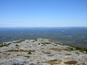
Mountain with a heart of cheese by Jim While I am sure it can be crowded, it wasn't crowded on the Birchtoft Red Spot Trail when I visited on a weekday, and the summit wasn't too terrible, either. Weekends are the busy time, and as a result, you'll need either a day pass for the park, which is limited by quota, or a campsite for the night to ensure access. See the park website for details.
Due to the location, I stayed in the campground. I was glad I did, as I hiked this instead of the two white trails, and saw only one other person on the trail all day. Most came from the white trails. The trail begins at the parking area located at the top of the hill just before you enter the campground. The lot is paved and next to a field. The trail itself is just down the road, and it enters the forest; it is not the paved trail that leads to some picnic tables. Initially, you will be hiking on part of the Pond Loop Trail. Shortly after crossing the road and re-entering the forest, you start to hike along the lake. There will be a sign for the Birchtoft Trail left away from the loop trail. The lower part of the hike is through a mix of red oak, sugar maple, birch, and white pine. It is very colorful in the fall. This part of New England was deforested and grazed in the early 19th century, and so there are numerous rock walls that you'll encounter as you hike up the lower mountain slopes. Around 1.25 miles in, you'll cross the Cascade Link Trail. This is basically the end of the Birchtoft Trail. Continue straight ahead, and you'll now be on the Red Spot Trail. The Red Spot Trail gets steeper as it gains altitude, and the forest converts primarily to red spruce. Eventually, you are hiking through a mixture of small boulders, rock steps, and friction slabs. Near the top of the ridge, the Red Spot ends, and you are on the Pumpelly Trail. You will follow the Pumpelly to the summit. Some elevation is lost crossing a small ravine as you near the summit. You may need to watch for the painted white "P" marking the trail in some areas, mostly noting them for your return to the trailhead. Excellent views on the summit await you, and the summit has ample space nearby if you find it too crowded. Return the way you came and watch for the other trails that leave from the top. Check out the Official Route and Triplog. Leave No Trace and +Add a Triplog after your hike to support this local community. | |||||||||||||||||||||||||||||||||||||||||||||||||||||||||||||||||||||||||||||||||||||||||