 Route Editor

| Guide | ♦ | 1 Triplog | 0 Topics |
details | drive | permit | forecast | route |
stats |
photos | triplog | topics | location |
| 30 | 1 | 0 |
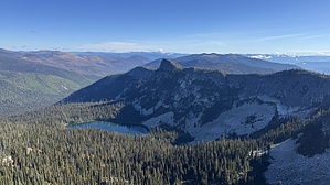
Ice Age Stunner by LindaAnn Hike The trail starts on the west side of the parking area near the end of FS2406. It is not well marked, just a narrow trail heading into the vegetation. As you head west, the trail begins to switchback uphill, reaching the edge of a cirque wall in about a mile. After that, the trail climbs a little more steeply along the edge of the cirque. There is a small lake below you to the north, but the views are obscured by the trees. There are great views to the south, though.
Returning down the short spur trail, the main trail heads northwest and begins the descent down to Myrtle Lake. The descent can be described as--steep, gradual, then steep again as you lose 1100' on your way to the lake. The trail reaches the lake near the southwestern shoreline, in a boggy area. Myrtle Lake does not seem to have much open shoreline, nor are there many use trails along the edge. There is a faint use trail along the southern edge of the lake, with a large campsite a little farther south. The creek running into the lake is pretty, with moss covering all the rocks. From the lake, retrace your steps back out. Regaining the 1100' is the only challenging part of the return, but after that, it is an easy hike back down to the trailhead. Note: This hike has a lot of trail crossing bare granite; use caution if hiking in wet or icy conditions. Be aware of possible bears or moose in the vicinity. Check out the Official Route and Triplog. Leave No Trace and +Add a Triplog after your hike to support this local community. One-Way Notice This hike is listed as One-Way. When hiking several trails on a single "hike", log it with a generic name that describes the hike. Then link the trails traveled, check out the example. | |||||||||||||||||||||||||||||||||||||||||||||||||||||||||||||||||||||||||||||||||||||


