Route Editor

| Guide | ♦ | 1 Triplog | 0 Topics |
details | drive | permit | forecast | route |
stats |
photos | triplog | topics | location |
| 39 | 1 | 0 |
hills are for geckos by LindaAnn Hike Line Point Trail #44 starts from a small parking area on the right side of FS-627. There is a large brown bulletin board marking the parking area. From there, walk north on the road about 50', and the trail appears on the right, with another brown sign. The first 0.75 miles are easy, as the trail parallels Skin Creek, heading gently uphill through the dense forest. At about 0.75 miles, the trail crosses the creek on a unique bridge made of wire mesh fastened to two large logs, with some wood railing.
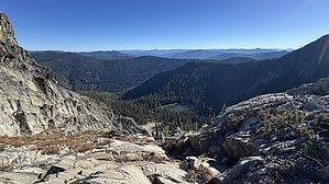
As you finally leave the switchbacks behind, the trees begin to dwindle in size, and the views open up. The Cabinet Mountains are visible to the south, and the Selkirk Mountains are visible to the west. The towns of Bonners Ferry and Moyie Springs are visible to the southwest. Perkins Lake can be seen immediately below. Just past 4 miles, you will reach a signed junction. Turn left to take the spur trail north to the summit of Goat Mountain. It's not any less steep, but the views are worth it. The summit is largely devoid of trees, with great 360-degree views. There are some places to sit among the rocks. From here, retrace your steps back downhill, or if you want a longer day, head east at the junction and continue along Trail 44. Both Reno Mountain and Line Point are nearby, and make for a solid day of hiking and views. Note As multiple signs will warn you, the Purcell Mountains have both black and grizzly bears. Stay aware of your surroundings. Check out the Official Route and Triplog. Leave No Trace and +Add a Triplog after your hike to support this local community. | |||||||||||||||||||||||||||||||||||||||||||||||||||||||||||||||||||||||||||||||||||||