 Route Editor

| Guide | ♦ | 1 Triplog | 0 Topics |
details | drive | permit | forecast | route |
stats |
photos | triplog | topics | location |
| 3 | 1 | 0 |
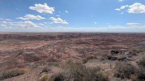
why is this a trail? by KingLeonidas   The Tawa Trail is a paved trail that runs 1.2 miles one way between Tawa Point and the Painted Desert Visitor Center. The Tawa Trail is a paved trail that runs 1.2 miles one way between Tawa Point and the Painted Desert Visitor Center.Trail Features & Route Description The trail starts (or ends, depending on direction) at Tawa Point, which is the starting point of the much more interesting Rim Trail. From Tawa Point, the paved trail traverses through grassland/desert plain, with interpretive signage in places, guiding you towards or away from the Painted Desert Visitor Center.
Trail Conditions & Useful Details The surface is paved and flat, making it suitable for families and strollers. . General Comments This trail seems more like a route to get park service staff from the visitors center and parking area to the Painted Desert Inn than a route designed for tourists/visitors. Despite this, the National Park Service lists it on the Petrified Forest website, in the "Things to do" section, under hikes. We were not very impressed and would not have bothered with it had we known what it was. Your time and energy are better spent on any one of the other trails in the park. Because of its location, it’s a great warm‐up or wind‐down hike — either starting your park visit here to acclimate or doing it as you depart, to soak in the landscape one more time. Check out the Official Route and Triplog. Leave No Trace and +Add a Triplog after your hike to support this local community. One-Way Notice This hike is listed as One-Way. When hiking several trails on a single "hike", log it with a generic name that describes the hike. Then link the trails traveled, check out the example. | |||||||||||||||||||||||||||||||||||||||||||||||||||||||||||||||||||||||||||


