 Route Editor

| Guide | ♦ | 1 Triplog | 0 Topics |
details | drive | no permit | forecast | 🔥 route |
stats |
photos | triplog | topics | location |
| 15 | 1 | 0 |
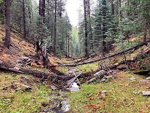
Rough Rider Options by kingsnake   McClintock Draw is a 2¾ mile long canyon just east of Dane Canyon, into which it empties. McClintock Draw is a 2¾ mile long canyon just east of Dane Canyon, into which it empties.Like most Rim canyons, McClintock Draw starts shallow and fairly wide. Unlike most of its neighbors, the head of McClintock Draw has a fair amount of deadfall. Not large; easily avoided.
The next quarter mile of McClintock Draw is a mild bushwhack. The Cabin Loop the draw after 1½ miles. If you take Cabin Loop (and FR 321C) back, it would be a 3.2-mile, 360-foot. AEG hike. Both options, as well as the main hike, are in the official GPS route. The final mile of McClintock Draw is more congested. Nothing too extreme, but more work and slower going. If you need to bail -- I saw evidence of flooding -- and are too far from Cabin Loop, go west (left): It’s not too steep, nor too high (80-100 ft.) or tangled. East (right) is more vertical and higher by over a hundred feet. When you reach the mouth of McClintock Draw, either climb out via animal trails, as I did, or loop back via Dane Canyon (overall a ~6.2 mi., 520 AEG loop). Check out the Official Route and Triplog. Leave No Trace and +Add a Triplog after your hike to support this local community. One-Way Notice This hike is listed as One-Way. When hiking several trails on a single "hike", log it with a generic name that describes the hike. Then link the trails traveled, check out the example. | ||||||||||||||||||||||||||||||||||||||||||||||||||||||||||||||||||||||||||||||||||||||||||||||||||


