 Route Editor

| Guide | ♦ | 1 Triplog | 0 Topics |
details | drive | no permit | forecast | route |
stats |
photos | triplog | topics | location |
| 14 | 1 | 0 |
My next project by kingsnake  Maricopa Wells is now on the Gila River Indian Reservation, about a day’s wagon train travel from Christmas Camp. So, this segment starts at the nearest possible point, ¼ mile from the Rez, nine miles west of Maricopa. Maricopa Wells is now on the Gila River Indian Reservation, about a day’s wagon train travel from Christmas Camp. So, this segment starts at the nearest possible point, ¼ mile from the Rez, nine miles west of Maricopa.0.0 mi.: It is one easy mile of dirt road, around a small hill, to pick up the trail (1.0), which manifests as a distinct wide spot between the creosote. After a half mile of trail, it peters out (1.5). I suspect wagon wear eventually turned into wash. Parallel to the south side of the shallow wash.
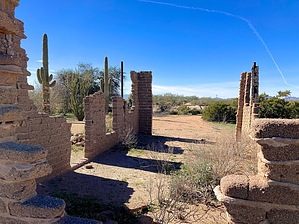
3.0 mi.: 83rd Ave. (also dirt). 3.5 mi.: Cross Waterman Wash. Head cross-country, aiming for the south tip of the tan-colored hill (the dump). 5.1 mi.: Arrive at the intersection of 91st Ave. and 99th Ave.(Hikebot thinks Butterfield Stage Rd), at the base of the dump. Lots of truck traffic. Check out the old brick building. If you need, a car could pick you up here, or down 99th Ave. at Mobile School. The trail heads to the southwest corner, but again, it has decayed to wash. (Switch between topo & sat views.) Make your way as best you can to Gas Pipeline Rd. 6.0 mi.: Rejoin the trail at the fiberglass post indicating the old forest road. Follow the road west. 9.7 mi.: The road bends north. At the fiberglass post, turn southwest. 10.3 mi.: On the edge of the Xmas Camp oasis, the road becomes very sandy. In 200 yds. is an intersection: Right to continue on trail, or access the corral/tank; left on also very sandy FR 8003 back to AZ-238. 12.4 mi.: AZ-238, just west of MP 26. Check out the Official Route and Triplog. Leave No Trace and +Add a Triplog after your hike to support this local community. One-Way Notice This hike is listed as One-Way. When hiking several trails on a single "hike", log it with a generic name that describes the hike. Then link the trails traveled, check out the example. | ||||||||||||||||||||||||||||||||||||||||||||||||||||||||||||||||||||||||||||||


