 Route Editor

| Guide | ♦ | 5 Triplogs | 0 Topics |
details | drive | no permit | forecast | route |
stats |
photos | triplogs | topics | location |
| 26 | 5 | 0 |
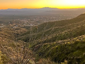
Wilderness in the City by DixieFlyer  Overview OverviewThe Wilderness Trail is a connecting trail in the Fountain Hills McDowell Mountain Preserve. It connects the Western Trail with the Sonoran Trail. Hike This guide describes the hike going from south to north, or from the Western Trail to the Sonoran Trail.
The Wilderness Trail is akin to a primitive trail that you might see in a wilderness area or in the backcountry of a national forest. It is narrow and has a number of steep, rocky sections. There is quite a bit of up-and-down as the trail goes into and out of drainages, and up and over some secondary ridgelines coming down from Peak 3804. It is recommended to wear good hiking footwear, and many people will find trekking poles useful on the trail. The trail is more appropriate for an experienced or intermediate hiker rather than a novice, casual hiker. If you hike the trail from north-to-south, add about 45-50 feet of elevation gain to the posted stats.
Check out the Official Route and Triplogs. Leave No Trace and +Add a Triplog after your hike to support this local community. One-Way Notice This hike is listed as One-Way. When hiking several trails on a single "hike", log it with a generic name that describes the hike. Then link the trails traveled, check out the example. | ||||||||||||||||||||||||||||||||||||||||||||||||||||||||||||||||||||||||||||||||||


