Route Editor

| Guide | ♦ | 2 Triplogs | 0 Topics |
details | drive | permit | forecast | route |
stats |
photos | triplogs | topics | location |
| 5 | 2 | 0 |
Canyons are inherently risky. Flash floods occur without notice on sunny days. Technical skills & surrounding topography knowledge required yet does not eliminate risk.
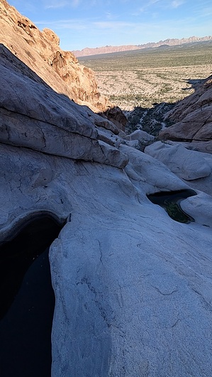
neat geology of granite potholes by azpinstripe  A fun scramble / very easy canyoneering trip down the historic Tinajas Altas -- one of the very few water sources in the region. A fun scramble / very easy canyoneering trip down the historic Tinajas Altas -- one of the very few water sources in the region.Overview Lots of different ways to enjoy these. Tinaja is Spanish for tank. There are 8-10 natural granite pools in this canyon that hold water for most of the year. Historical for many reasons, apparently, lots of people in the 1800s and early 1900s died trying to get to this water source. There is evidence in the higher Tinajas of human visitation, shown by metal pipes and stakes drilled into the rock in various places. Very neat geology and a fun activity, kind of reminiscent of a very-poor-mans 7 Teacups canyon in California.
Ascent options From the parking, it is an easy 3-minute walk through some boulders to the lowest Tinaja (often nasty water). To begin ascending to the top via the more technical route, you can scramble up the first cliff on the right or the left, then generally stay left as you keep going up, with a good amount of 4th and low 5th-class moves. The other option would be to hike up the side canyon 75 yards directly to the north to get to the top of the Tinajas. Descent There are a few different rappel anchors consisting of newer bolts, old slings, really old drilled pipes, iron stakes, and some gear anchors with nuts and webbing. Lots of these rappels are optional; in many places, you can just walk/scramble down the steep slab instead of rappelling. The biggest and steepest rappel is roughly halfway down; from 2 bolts, it lands you in an isolated pool with a sketchy single nut anchor to escape the pool. It's best to just continue rappelling to skip that anchor. I think at most the entire descent could be 6 rappels. 1 70m rope is perfect for descending the longest rappel; you only need 1 rope. Other Occasional illegal activity in this area with drug packers/smugglers. I would imagine at times some of them stop at the Tinajas to get water, but I didn't notice any signs (e.g., discarded foreign trash like what is often encountered near Baboquivari and similar areas). I talked to a Border Patrol agent driving by, and he said the area was safe; the people involved in smuggling do not want interactions with anyone or to be seen, and they avoid everyone. Also, this is a former bombing range, and there is exploded (and presumably unexploded) ordinance in the area, so don't touch anything you see like that. Check out the Official Route and Triplogs. Leave No Trace and +Add a Triplog after your canyon trip to support this local community. | |||||||||||||||||||||||||||||||||||||||||||||||||||||||||||||||||||||||||||||||||||||||||