Route Editor

| Guide | ♦ | 1 Triplog | 0 Topics |
details | drive | no permit | forecast | route |
stats |
photos | triplog | topics | location |
| 10 | 1 | 0 |
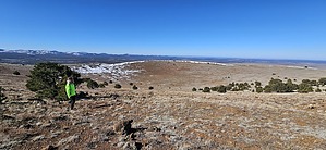
Get cratered! by azbackpackr   This hike is short, very steep, and can be done in a couple of hours, though it's good to allow a bit more time to take in the views. Invisible from the highway, there's a sizeable crater at the top of the mountain. There are two FM radio towers on top. One is on the actual summit. This mountain is known as a "cinder cone," a type of volcano that spits out mostly hot cinders when it erupts, as opposed to the type that spews lava, which then becomes basalt formations. The age of it is anywhere from about 300,000 to 2 million years--Pleistocene epoch. While parts of it are bare cinders, it also has a shaggy mane of piñon-juniper. This hike is short, very steep, and can be done in a couple of hours, though it's good to allow a bit more time to take in the views. Invisible from the highway, there's a sizeable crater at the top of the mountain. There are two FM radio towers on top. One is on the actual summit. This mountain is known as a "cinder cone," a type of volcano that spits out mostly hot cinders when it erupts, as opposed to the type that spews lava, which then becomes basalt formations. The age of it is anywhere from about 300,000 to 2 million years--Pleistocene epoch. While parts of it are bare cinders, it also has a shaggy mane of piñon-juniper.Hiking directions Drive in through the open gate and park near it. (There is a cattle guard there, no actual gate to open and close.) Although it's on state land, no permit is required. Hike up the road to the top. There are a couple of splits; take the left, or the more traveled road. Less than a mile in, at a T-intersection with a gate, take the left, and go through the gate.
At the top, you'll see one of the main White Mountains ridges, to the south, with Greens Peak being the main prominence. Whiting Knoll is close by, and many other prominences are visible. On the southeastern horizon looms Escudilla Mountain. Vast grasslands lie to the northwest, north, and east. New Mexico is close by. On a clear day, you can see Alegres Mountain, 10,234 feet on the Continental Divide, near Pie Town, NM. Also visible through the haze is Escondido Mountain, 9,860. A little north of the summit tower is a small pile of rocks where you will find a peak register, well-hidden. Please just sign and date, and replace carefully. Any comments should be very brief, no more than a short sentence. These registers are a very old tradition amongst hikers, but are disappearing. Some of these register jars have been in place for many decades. Retrace your steps back to the car. Geologic information This cinder cone is part of the Springerville Volcanic Field, which is the 3rd-largest volcanic field in the lower 48 states. The vulcanism occurred during the Pleistocene age. It has been much-studied by various departments of nearby universities in Arizona, New Mexico, and also by the Smithsonian. The Springerville Volcanic Field: • Wikipedia • 13MB PDF Geological Study Gate Policy: If a gate is closed upon arrival, leave it closed after you go through. If it is open, leave it open. Leaving a closed gate open may put cattle in danger. Closing an open gate may cut them off from water. Please be respectful, leave gates as found. The exception is signage on the gate directing you otherwise. Check out the Official Route and Triplog. Leave No Trace and +Add a Triplog after your hike to support this local community. | |||||||||||||||||||||||||||||||||||||||||||||||||||||||||||||||||||||||||||||||||||||