Route Editor

| Guide | ♦ | 4 Triplogs | 0 Topics |
details | drive | no permit | forecast | route |
stats |
photos | triplogs | topics | location |
| 53 | 4 | 0 |
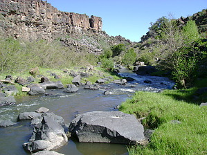
hop along by azbackpackr  This is an unofficial trail down a section of the upper Little Colorado River gorge, which eventually connects to the Powerhouse Trail. You can return the way you came, or if two vehicles are available, you can go one way. This is an unofficial trail down a section of the upper Little Colorado River gorge, which eventually connects to the Powerhouse Trail. You can return the way you came, or if two vehicles are available, you can go one way.Starting at a roadside rest on US 60, near Becker Lake in Springerville, we'll make our way down a grassy slope, looking for a chainlink fence opening for hikers, in a corner of the fence. Then on down the slope, through another opening in the fence, and to the dam. Just below the dam, look for a good place to hop across the little river, on big rocks.
Check out the Official Route and Triplogs. Leave No Trace and +Add a Triplog after your hike to support this local community. | |||||||||||||||||||||||||||||||||||||||||||||||||||||||||||||||||||||