Route Editor

| Guide | ♦ | 1 Triplog | 0 Topics |
details | drive | no permit | forecast | map |
stats |
photos | triplog | topics | location |
| 5 | 1 | 0 |
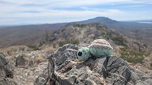
A unique hike along the ridge of Caballo Cone by agrove731 If you’re in Truth or Consequences, set aside a morning for this unique hike. It’s not difficult in terms of elevation gain or distance, but it is technically very interesting. It’s also empty of hikers, even on a weekend, and with its proximity to town. A short drive along the river, then cross the bridge and drive back along the opposite bank for a bit. Right after a cattle guard, park on the left. There appear to be two trails, but they converge quickly.
Start the hike and take a steady pace. It’s pretty much all uphill with about 4 or 5 false summits. The best part is when the mountain falls away, and you’re forced to climb across the literal ridge—it can’t be more than a couple of feet wide. At the final summit, you can see the whole town and the nearby reservoir as well. There’s a geocache up there. I left a map of the White Tank Mountains and some electrolytes I had in my pack. The journey back is much quicker, but your knees will definitely benefit from trekking poles. There’s not much relief in either direction from constant uphill or constant downhill. Warning The entire hike is exposed with no shade whatsoever. A seasoned Arizona hiker would do fine. Hikers with less experience in this climate should ensure to bring more water than they need and wear appropriate sun protection. Note Make sure to book a soak at one of the hot springs in town for after your hike, you won’t regret it! Check out the Triplog. Leave No Trace and +Add a Triplog after your hike to support this local community. | ||||||||||||||||||||||||||||||||||||||||||||||||||||||||||||||||||||||||||||||||