Route Editor

| Guide | ♦ | 1 Triplog | 0 Topics |
details | drive | no permit | forecast | route |
stats |
photos | triplog | topics | location |
| 0 | 1 | 0 |
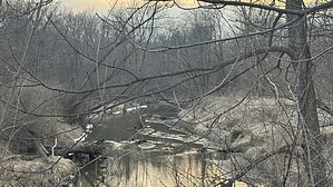
Iowa or bust! by LindaAnn Hike: From the Tom Harkin Trailhead, head west on the signed path. It immediately runs under a bridge, and on the other side, splits to begin the loop. While hikers can walk the loop in either direction, bikes must travel clockwise per the signage. As you head west, the trail runs along the north bank of Clear Creek. It is mostly flat and in good condition. Potential wildlife includes deer, squirrels, raccoons, geese, and a variety of other birds. Plenty of trees provide shade during the summer.
At the east end of the loop, the trail joins back together, passes under the bridge again, and finishes back at the trailhead. This is an easy hike, in town, but with a little bit of nature. Check out the Official Route and Triplog. Leave No Trace and +Add a Triplog after your hike to support this local community. | ||||||||||||||||||||||||||||||||||||||||||||||||||||||||||||||||||||||||||||||||||||||