 Route Editor

| Guide | ♦ | 2 Triplogs | 0 Topics |
details | drive | no permit | forecast | route |
stats |
photos | triplogs | topics | location |
| 0 | 2 | 0 |
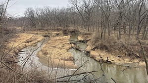
Far away from Alice's restaurant by LindaAnn  Clear Creek Trail is a paved multi-use path that roughly parallels Clear Creek from the Iowa River west to the outskirts of Tiffin, IA. It can easily be accessed from multiple points along the trail. Hike This guide follows the trail from east to west, but there are numerous access points along the way, and it can be traveled in either direction for the distance of your choosing. Clear Creek Trail starts on the west bank of the Iowa River, where Clear Creek meets the river, at the junction with the Iowa River Trail. Heading west on the paved path, the trail runs along the north side of Clear Creek. The trail passes under two bridges, and then thru a large, paved, circular area. After that, the trail makes a sharp left and turns south.
At the southwest corner of the soccer fields, the trail turns north again and is signed. There is a sign for the Mormon Handcart Trail, which is worth the short side trip. After that, head northwest as the trail skirts the edge of the University's cross-country course. Once past the university grounds, the trail meanders west-northwest along Clear Creek. You'll cross a few roads, but signage is better as you head west. Just shy of six miles, the trail passes under I-80. A short while later, it goes under I-380 and then turns more to the west, still following the creek. You'll then walk thru Tiffin City Park, and south around the dog park before turning west along the creek again. The trail ends on the west at a parking lot on Half Moon Ave. Check out the Official Route and Triplogs. Leave No Trace and +Add a Triplog after your hike to support this local community. One-Way Notice This hike is listed as One-Way. When hiking several trails on a single "hike", log it with a generic name that describes the hike. Then link the trails traveled, check out the example. | |||||||||||||||||||||||||||||||||||||||||||||||||||||||||||||||||||||||||||||||||||||


