Overview
This hike is along a section of the Black Canyon Trail (BCT) starting at the Black Canyon City (BCC) trailhead and going south as far as the Little Pan trailhead. Information and history about the BCT can be found at www.bctaz.com. The hike is through desert scrub with numerous Saguaros and views in many directions as you wind around the hills. You cross the Agua Fria River twice during the hike and you should be prepared for high water in the spring or after heavy rains. Be aware of snakes on or near the trail as this is snake country.
Hike
This hike is best done with a car shuttle. There are two points to spot a car at the south end: either at the Table Mesa Road trailhead (12.7-mile hike) or the Little Pan trailhead (10.0-mile hike). We chose to use the latter after we were able to locate the dirt access road in on our GPS maps and wanted the shorter hike after a two-week layoff. Leaving the BCC trailhead you pass a sign-in register and go through a gate. The trail is well-worn and easy to follow but can get a little confusing in a couple of areas where there are numerous jeep trails. It is closed to motorized vehicles but gets plenty of use from hikers and mountain bikers. At about .9 miles you will come to a fork in the trail. The right fork takes you north on the K-Mine section of this trail. For the hike, I'm describing you'll want to go left. Also, you'll get a view of the Agua Fria River and Horseshoe Bend below. Continue, descending to the river level. As you approach the flat, sandy area at about 1.5 miles look across the rocks toward the river to spot where the trail ascends the embankment. There is a BCT sign there and this is your crossing point. There are some rocks there that you can use to cross and stay dry, but when the water is high your feet will get wet. If you don't want to get your boots wet, bring extra water shoes or sneakers to use crossing the river.
After crossing the river the trail swings left. After a short climb, it turns right and then right again. Watch for BCT signs pointing the way as this area has several jeep trails. At about 1.6 miles (N34 02.495 W112 09.791) there is a fork in the trail. Go left. You'll see a white sign further down the trail which is a BCT sign pointing the way, but it is too far away at the fork to be readible. From here the trail is less confusing and gradually climbs the hill ahead of you with numerous switchbacks. It goes around the backside of the hill and continues climbing with many more long switchbacks. The trail snakes all over the place following the contours of the hills and valleys. There are several places with great views down the river, toward Black Canyon City, and the southern Bradshaws. For a while, the trail goes northwest which is opposite the direction you think you should be going. Eventually, it does round the hills and heads south toward your destination. At 3.65 miles (N34 02.651 W112 10.381) you reach the high point of the hike. For those not wanting to go on to Little Pan Loop this would be a good turnaround spot. From here the trail snakes around the hills some more and goes generally downhill. At 6.2 miles (N34 02.434 W112 11.379) you cross a jeep road; follow the signs across the road to stay on the trail. At 6.8 miles (N34 02.063 W112 11.537) you cross a wash; follow the trail diagonally across the wash. At 7.1 miles (N34 01.914 W112 11.455) you cross another road; follow the trail across the road. At 8.6 miles (N34 01.330 W112 11.014) you reach the top of Little Pan Loop. If you parked at Table Mesa Road trailhead you could take either side of the loop. If you parked at the Little Pan Loop as we did, you would want to go left from the intersection. Following the signs as the trail goes downhill to the dirt road on the left. Turn right on the road as the trail follows it for a while. Keep your eyes open for a BCT trail sign indicating a sharp right in less than a mile indicating where the trail leaves the road and goes down to the river. Continue following the signs and cross the river at N34 00.857 W112 10.711. Turn left leaving the trail and hike in the sand until you see a steep sandy jeep trail up the embankment to the right. This should lead you back to your car at N34 00.947 W112 10.413 if this is where you parked. It's a good idea to "mark" your car's GPS position when you park it so you can find it back here. There are a lot of jeep trails and parking areas. The place was surprisingly busy for a weekday when we did the hike. We saw several ATVs, jeeps, other 4wheel drive vehicles, and a sheriff.
Gate Policy: If a gate is closed upon arrival, leave it closed after you go through. If it is open, leave it open. Leaving a closed gate open may put cattle in danger. Closing an open gate may cut them off from water. Please be respectful, leave gates as found. The exception is signage on the gate directing you otherwise.
When hiking several trails on a single "hike", log it with a generic name that describes the hike. Then link the trails traveled, check out the example.
WARNING! Hiking and outdoor related sports can be dangerous. Be responsible and prepare for the trip. Study the area you are entering and plan accordingly. Dress for the current and unexpected weather changes. Take plenty of water. Never go alone. Make an itinerary with your plan(s), route(s), destination(s) and expected return time. Give your itinerary to trusted family and/or friends.
Permit $$
None
Directions
Road
Strictly 4x4
To hike Black Canyon City trailhead: The Black Canyon City Trailhead has ample parking space for cars and vehicles with trailers, but no amenities and no camping is allowed. From Interstate 17, in either direction; take exit 242 (Black Canyon City and Rock Springs), turn west, proceed to the stop sign, turn north (right) on the frontage road, drive about 300 ft to the first road on the left, Warner Rd, and turn left. Drive about 1300 ft to the first crossroad, turn right and proceed to the parking area on the right near the end of the road, about 400 ft. GPS coordinates, using NAD27 Datum: N34 3.140' W112? 9.048'
Table Mesa Road trailhead: This is presently an undeveloped trailhead with limited parking. However, there is ample parking within easy walking distance a short way up the side road. Trailhead signs are occasionally vandalized and removed, so it will be necessary to check your odometer and watch carefully for the side road to the right. From Interstate 17 take exit 236 (Table Mesa Rd), turn west then north on the frontage road, drive approximately 1.65 miles to the "Y" and bear left, drive approximately 1.38 miles and look for the side road on the right. Turn onto this road and the trailhead is immediate to the left. GPS coordinates, using NAD27 datum: N33 59.076' W112? 10.063'
Little Pan Loop trailhead: Directions to this trailhead don't appear on the BCT website so these are my own. I have also posted a track from I-17 to the trailhead. This is a high-clearance 4WD road. Proceed as if you were going to the Table Mesa Road trailhead above. At 1.65 miles (N33 59.162 W112 08.721) take the right fork which is relatively straight ahead. After crossing under powerlines take the next road to the left at about 2.5 miles (N33 59.649 W112 08.906). Stay on the main track. You'll pass through a cattle guard and later a gate which you must open and then close when you have passed through. After a steep ascent and then descent you come to a large parking area on the right. Proceed through it to a lower parking area with lots of shell casings laying around and a fire ring or two. Park in this area (N34 00.947 W112 10.413) about 4.7 miles from the I-17 ramp.
 Route Editor


 Overview
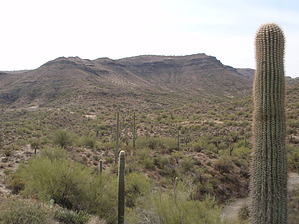


