 Route Editor

| Guide | ♦ | 1 Triplog | 0 Topics |
details | drive | permit | forecast | route |
stats |
photos | triplog | topics | location |
| 0 | 1 | 0 |
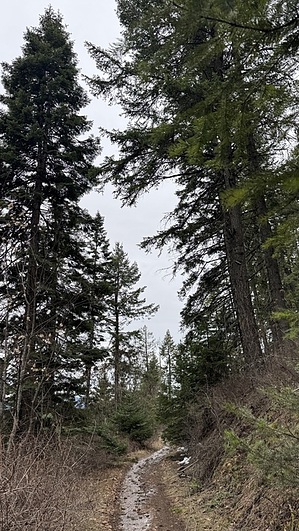
Abundant fresh air by LindaAnn Hike: Trail 6 is a short connecting trail between Trail A on the west end and the junction of Trail 1562 and Trail 7 on the east end. Starting from the west end, the trail is all uphill on a moderate grade. The start of Trail 6 is not well marked; it peels off the left fork from Trail A and starts to head uphill on an old logging road.
Continuing east, and gradually climbing, you'll pass thru a gate near the east of the trail. Shortly after the gate, you will reach the junction with Trail 1562 (which runs east-west across the entire trail system) and Trail 7 (which heads south and steeply downhill). The closest trailhead to Trail 6 is Nettleton Gulch. Parking at the nearby trailheads seems to be limited to daylight use only. Gate Policy: If a gate is closed upon arrival, leave it closed after you go through. If it is open, leave it open. Leaving a closed gate open may put cattle in danger. Closing an open gate may cut them off from water. Please be respectful, leave gates as found. The exception is signage on the gate directing you otherwise. Check out the Official Route and Triplog. Leave No Trace and +Add a Triplog after your hike to support this local community. One-Way Notice This hike is listed as One-Way. When hiking several trails on a single "hike", log it with a generic name that describes the hike. Then link the trails traveled, check out the example. | |||||||||||||||||||||||||||||||||||||||||||||||||||||||||||||||||||||||||||||||||||||


