 Route Editor

| Guide | ♦ | 1 Triplog | 0 Topics |
details | drive | no permit | forecast | map |
stats |
photos | triplog | topics | location |
| 4 | 1 | 0 |
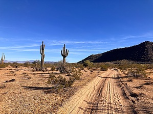
Bring carrots just in case by mt98dew  Overview OverviewThe Paloma Regional Preserve is a new park that opened in October 2020. The park comes loaded with amenities, including a dog park (actually 2, one for big dogs and one for small), baseball fields, a splash park, fishing, picnic tables, pickleball courts, bathrooms, drinking fountains, and even a few trails. The trails were one of the last features added, and it seems to still be a work in progress. In addition to adding 11 new trails, they’ve changed the names of the trails that traverse West Wing Mountain. (The trails are the same on West Wing Mountain; they have just given different segments of trails their own name). The park and all the above amenities are accessed via N Lake Pleasant Rd. Not including the TH described in the West Wing Mountain description, 3 trailheads access the new trails that are part of the Paloma Regional Preserve (PRP). One is located at the East Wing TH, and the other 2 are located in Paloma Park on the west end of the preserve. (The preserve extends between East Wing TH and Paloma Park). The East Wing TH, though not as large, has a few amenities of its own, including bathrooms, basketball courts, a playground, drinking fountains, and a trail map of the area (located at the trailhead). The Burro Range Trail is most easily accessed from the East Wing TH. There is parking for about 20 cars, and the TH is located at the northwest edge of an open field.
Many of the trails that make up the Paloma Regional Preserve are trails that have been repurposed as “new” trails for the Preserve. This can lead to confusion as there are numerous unnamed paths and roads in the Preserve created by hikers, bikers, and off-road enthusiasts long before the Preserve existed. Hike This trail is an interior trail, so some additional hiking is required. The easiest way to access this trail is via the East Wing TH. Start by taking the Biscuit Flat (BF) Trail .4 miles to reach the beginning of the Biscuit Flat Loop. Take the BF going clockwise. At 0.6 miles, there is a split in the BF Trail; continue following it north. Around 1 mile, you’ll reach a trail marker and the beginning of the Burro Range Trail. The Burro Range (BR) Trail is an incredibly easy trail. Basically, it’s a road. Stay on the road, and you’re doing the BR Trail. The trail starts in a NNW direction. Initially, it feels like you are hiking in a sandy trough with 6-inch banks. The sand and banks don’t last long, transitioning into compact dirt with a flat, wide open desert around you. There really isn’t too much to catch your eye. The desert is pretty barren with a scattering of Palo Verdes, saguaro, creosote, and the like. Distant views are a little better, with the Bradshaws to the north and East and West Wing Mountains to the south. Unfortunately, you also have homes lining your view to the east and south as well. At around 0.4 miles, the “trail” merges with another trail/road and takes on a more northward heading. There are some slight curves to this trail, but for the most part, it is straight. One of the “nice” things about this trail is that it is very flat and almost completely rock-free. At 0.81 miles, the trail ends when it junctures with the New River Trail. Altogether, it’s taken about 1.8 miles to reach this point. You have several options. None of which are overly exciting. You can return the way you came for about a 4-mile hike, continue on the New River Trail (which is also a dirt road), or decide to follow one of the many use trails that spiderweb through this open desert. Water Sources There are drinking fountains at both the East Wing TH as well as Paloma Park on the west end. Synopsis This is another hard sell for Paloma Preserve. There is nothing about the Burro Range that makes you think trail. It’s unimaginative and seems to be an easy out for the city of Peoria to add a trail to their system. At best, this is a nice trail for runners, but this trail will be a one-and-done for most people.
Check out the Triplog. Leave No Trace and +Add a Triplog after your hike to support this local community. One-Way Notice This hike is listed as One-Way. When hiking several trails on a single "hike", log it with a generic name that describes the hike. Then link the trails traveled, check out the example. | |||||||||||||||||||||||||||||||||||||||||||||||||||||||||||||||||||||||||||||


