Overview: Westwood Loop NE is one of the trails in the city of Rathdrum's extensive network of StormKing Trails. Nearly any combination of trails can be hiked in the network, allowing you to create as easy or as difficult a hike as you desire.
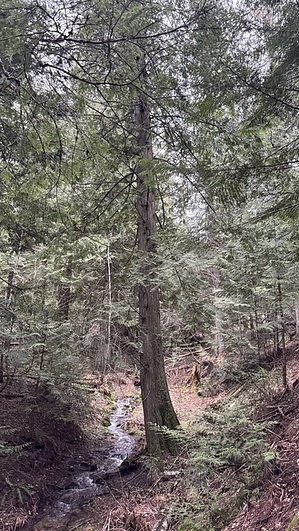
Hike: Starting from the entrance to the main parking lot, Westwood Loop heads northwest along the right bank of South Fork Spring Branch Creek. The trail heads gently uphill, paralleling the creek. The forest is dense, and no matter how sunny the day, the trail will be mostly shaded.
As the trail heads uphill, there are several opportunities to walk down to the edge of the creek. Picnic spots are obvious, and many people opt to just walk a short distance and sit at the water. Views along this trail are quite limited, but the variety of vegetation is very pretty--it's basically a Pacific Northwest rainforest along this trail.
Westwood Loop ends at the junction with Skyline and Frog Spit trails, which both continue uphill.
When hiking several trails on a single "hike", log it with a generic name that describes the hike. Then link the trails traveled, check out the example.
WARNING! Hiking and outdoor related sports can be dangerous. Be responsible and prepare for the trip. Study the area you are entering and plan accordingly. Dress for the current and unexpected weather changes. Take plenty of water. Never go alone. Make an itinerary with your plan(s), route(s), destination(s) and expected return time. Give your itinerary to trusted family and/or friends.
Permit $$
None
Directions
Road
Paved - Car Okay
To hike From Hwy 53 in Rathdrum, head northwest on McCartney St about 1.5 blocks to Oneida St. Turn right on Oneida and head north to Reservoir Rd. Turn left on Reservoir, and follow it to Barrett Dr. Left on Barrett to where it ends at the main parking lot.
 Route Editor


