 Route Editor

| Guide | ♦ | 1 Triplog | 0 Topics |
details | drive | no permit | forecast | route |
stats |
photos | triplog | topics | location |
| 0 | 1 | 0 |
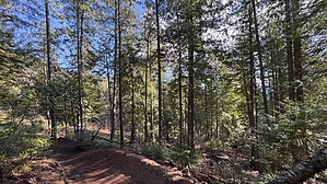
Quick Spin by LindaAnn Hike: The lower part of Hi Frequency starts from a junction with Skyline Trail, just above the junction with South Fork Passage. The trail climbs uphill, heading west. The trail surface is good, and the trail is a little steeper than some of the others in the trail system. Obviously designed for mountain biking, the trail meanders back and forth, taking advantage of the terrain.
Note: If you are planning to continue uphill on Rathdrum Mountain, this is a handy trail that eliminates a lot of the lower road walk on StormKing Pkwy. Check out the Official Route and Triplog. Leave No Trace and +Add a Triplog after your hike to support this local community. One-Way Notice This hike is listed as One-Way. When hiking several trails on a single "hike", log it with a generic name that describes the hike. Then link the trails traveled, check out the example. | ||||||||||||||||||||||||||||||||||||||||||||||||||||||||||||||||||||||||||||||||||


