 Route Editor

| Guide | ♦ | 1 Triplog | 0 Topics |
details | drive | no permit | forecast | route |
stats |
photos | triplog | topics | location |
| 20 | 1 | 0 |
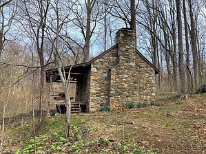
Launching the Rollercoaster by kingsnake  From the trailhead an access spur drops 100 yds. to an “Appalacian Trail” [sic] sign. Turn right (north). 1.3 mi. The first branch of Hidden Hollow that the trail crosses. The second branch is by the cabin.
Left to Glaser Cabin; straight to stay on main trail. Both choices are the same distance and gain. Fwiw, the cabin (and outhouse) is locked for Potomac Appalachian Trail Club members only. Good place for a family picnic, though, as it has a table and swing. 2.6 mi. Duke Hollow has an old stone wall on its north bank. 3.3 mi. Rod Hollow has boardwalks on either side of the shelter spur. The shelter has two decks. (upper accessible by ladder), two fire pits. a picnic cabana, at least three gravel tent pads, and an unlocked outhouse. The famous "Rollercoaster" starts just past the shelter. The Rollercoaster is a series of at least eight steep 300-500 ft. climbs, back to back, over the next eight miles or so to Snickers Gap. (Note this hike only goes another 3.8 miles.) 5.0 mi. Morgan Mill Stream. The second Coaster climb to the top of Piney Ridge, which had a bit of a view to the east, towards the summit of Mount Weather. 6.5 mi. Ashby Hollow. There’s a small wooden bridge over the creek, which is paralleled by a decent gravel road. No idea where that goes. 7.1 mi. The trailhead on Morgan’s Mill Rd. is 150 yds. west of the trail. Continuing the remainder of The Rollercoaster is another 6.9 mi., 1900 AEG. Check out the Official Route and Triplog. Leave No Trace and +Add a Triplog after your hike to support this local community. One-Way Notice This hike is listed as One-Way. When hiking several trails on a single "hike", log it with a generic name that describes the hike. Then link the trails traveled, check out the example. | |||||||||||||||||||||||||||||||||||||||||||||||||||||||||||||||||||||||||||


