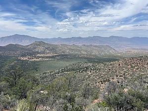
Del Shay Basin is a remote and rugged off-trail area of TNF. Access can be made from the Del Shay Cabin area, FS649, or FS1938. The entire area is littered with historic sites ranging from “modern” cowboy ranching to ancient Indian dwellings.
There are magnificent views in all directions and endless stream beds. The terrain is unforgiving at best, and there is no water available. The 4x4 roads accessing the area are strictly high clearance Four Wheel Drive and can be very rough, slow going.
Hiking in the basin requires very steep, loose terrain going up if coming from the west or very steep, loose terrain going down if coming from the east. The Del Shay Cabin “trail” is the only established route near the basin; all other travel is bushwhacking off-trail.
WARNING! Hiking and outdoor related sports can be dangerous. Be responsible and prepare for the trip. Study the area you are entering and plan accordingly. Dress for the current and unexpected weather changes. Take plenty of water. Never go alone. Make an itinerary with your plan(s), route(s), destination(s) and expected return time. Give your itinerary to trusted family and/or friends.
Permit $$
None
Directions
Road
Strictly 4x4
To hike State HWY 188 to Tonto Basin, go across the bridge to FS71, take either FS604 to FS649 or FS609 to FS1938. The 3rd option is from Jake’s Corner to the Del Shay cabin TH.
 Route Editor

 Del Shay Basin is a remote and rugged off-trail area of TNF. Access can be made from the Del Shay Cabin area, FS649, or FS1938. The entire area is littered with historic sites ranging from “modern” cowboy ranching to ancient Indian dwellings.