 Route Editor

| Guide | ♦ | 1 Triplog | 0 Topics |
details | drive | no permit | forecast | 🔥 route |
stats |
photos | triplog | topics | location |
| 15 | 1 | 0 |
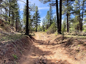
A smorgasbord of signs by kingsnake   From the people-only v-gate, Trail #508 heads southeast for a half mile, then disappears as it turns south up Cottonwood Wash. Angle 200 yds. left, across the wash, to pick up an unnumbered jeep trail. After 2½ miles, at Gourd Flat Canyon, the route splits left onto FR 132B (the less obvious option). After 3½ miles, by the ranch, the route splits right off FR 132B, between -- but not on -- the two jeep trails, turning back to foot trail, along the east flank of Butler Point. From the people-only v-gate, Trail #508 heads southeast for a half mile, then disappears as it turns south up Cottonwood Wash. Angle 200 yds. left, across the wash, to pick up an unnumbered jeep trail. After 2½ miles, at Gourd Flat Canyon, the route splits left onto FR 132B (the less obvious option). After 3½ miles, by the ranch, the route splits right off FR 132B, between -- but not on -- the two jeep trails, turning back to foot trail, along the east flank of Butler Point.Trail #508 climbs up a small wash to Bald Point. I briefly lost the trail again, just before it joins FR 163 at 4⅓ miles. FR 163 passes through an open gate to Scrub Point. The route splits right off FR 163 at just over 5 miles. The route drops 150 ft. to the bottom of Bryant Canyon. The route then climbs up Bryant Canyon, ending after just under 7 miles at FR 132.
Gate Policy: If a gate is closed upon arrival, leave it closed after you go through. If it is open, leave it open. Leaving a closed gate open may put cattle in danger. Closing an open gate may cut them off from water. Please be respectful, leave gates as found. The exception is signage on the gate directing you otherwise. Check out the Official Route and Triplog. Leave No Trace and +Add a Triplog after your hike to support this local community. One-Way Notice This hike is listed as One-Way. When hiking several trails on a single "hike", log it with a generic name that describes the hike. Then link the trails traveled, check out the example. | |||||||||||||||||||||||||||||||||||||||||||||||||||||||||||||||||||||||||||||||||||||||||


