Route Editor

| Guide | ♦ | 1 Triplog | 0 Topics |
details | drive | no permit | forecast | map |
stats |
photos | triplog | topics | location |
| 14 | 1 | 0 |
Canyons are inherently risky. Flash floods occur without notice on sunny days. Technical skills & surrounding topography knowledge required yet does not eliminate risk.
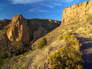
Go prepared! - Caving Checklist Apache treasure by PrestonSands  The entrance to Apache Box is accessible via a rough four wheel drive road; consequently, the length of any hike to Apache Box can vary from one to five miles, or more, round trip, depending on your vehicle, determination, and time. The description here will begin near the divide between the Apache Creek and Bitter Creek watersheds, which seems like as good a place as any to begin your hike.
Hike: Turning off of the Bitter Creek Road onto the private ranch property, the road to Apache Box travels northeast, past trailers and a couple of homes. Leaving the private ranch property and arriving on B.L.M. land, the road gets really rough, and there are a couple of welcome ridge top parking spots, about 1.5 miles from the Bitter Creek Road. These parking spots make an ideal place to start hiking. A half mile or so beyond the parking spots, the road forks. Go right, uphill. The road to Apache Box slowly climbs north, below an increasingly steep mountainside to the right. Straight ahead, the enormous cliffs of Apache Box grow closer. Behind the Box, the peaks of the Big Lue Mountains appear quite tame, rising above the grasslands of the Apache Creek basin. Soon the road passes below a massive cliff to the right, and comes to a small turnaround spot at the entrance to Apache Box, 3.4 miles from Bitter Creek Road. The four wheel drive road ends here, and a signpost identifies the area behind it as a Bureau Of Land Management Wilderness Study Area. A very steep and rocky trail continues on however, switchbacking down into the deep confines of Apache Box. From the switchbacks, one can see several caves in the cliffs above, which appear to be quite difficult to access. Prehistoric artifacts have been recovered from at least one of the caves. Reaching the floor of Apache Box, the road disappears into the creek bed. This is not a place to get caught during a flash flood. Heading downstream, one soon comes to the old adits of the Apache Box Canyon Mine, at the foot of the cliffs. Bats now call the tunnels home. Upstream and downstream from where the road ends in the bottom of Apache Box, waterfalls are sure to exist. Be careful, and give yourself plenty of time to explore this rugged and beautiful place. Check out the Triplog. Leave No Trace and +Add a Triplog after your canyon trip to support this local community. | ||||||||||||||||||||||||||||||||||||||||||||||||||||||||||||||||||||||||||||||||||||||||||