Route Editor

| Guide | ♦ | 19 Triplogs | 0 Topics |
details | drive | no permit | forecast | 🔥 route |
stats |
photos | triplogs | topics | location |
| 144 | 19 | 0 |
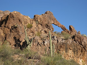
Can Treasure Be Far Away by AZLOT69  2022 2022A couple of pretty good trails take you from the road up to the arch. Very easy to follow. Overview The symbol of an Elephant historically represents great strength, wisdom, longevity, happiness, royalty, good luck, and ambition. If you have done your homework you would be quick to acknowledge that any or all of these characteristics would be an asset to any adventurer in the Superstition Mountains. Elephant Arch stands guard along the Rogers Trough Road, which is one of the major gateways into the Superstition Mountains.
Hike The hike is entirely off-trail. The bushwhack up, will involve encounters with typical Arizona plants that stick, poke, and scratch. Long pants and sleeves are a plus and are very careful during snake season. The arch is visible from the trailhead but hard to distinguish from this angle due to a backdrop of rock outcroppings. Just north of the trailhead is a dip in the road. Start the hike in this wash going up to the west. It involves some rock hopping to start with but quickly comes to a smooth rock section that while uphill is easily navigated. The arch can be seen now above you on the right. The wash becomes overgrown. Continue up along the right bank of the wash watching for an opening in the vegetation to make a beeline towards the base of the rock supporting the arch. Once at the base follow it to the left and up, climbing onto this pedestal. Continue around to the right like you are on a spiral staircase to look at the arch and your vehicle at the trailhead below. There is a natural rock vantage point crow's nest, (like from a pirate ship) above and just west of the arch for you to enjoy 360-degree views. The arch is situated on flat ground upon its pedestal offering photo opportunities from all angles. Plenty of seating makes this a great lunch spot. At about 20 feet wide and ten feet tall it is quite fragile with the thinnest section less than 12 inches in diameter. Please stay off the arch and treat it responsibly including pack it in, pack it out. With karma intact make a loop out of it by facing the road and descending via the wash on your left. It's pretty easy going after the initial downclimb off the pedestal. This wash takes you to the road and your transportation is just a short distance to the right. Gate Policy: If a gate is closed upon arrival, leave it closed after you go through. If it is open, leave it open. Leaving a closed gate open may put cattle in danger. Closing an open gate may cut them off from water. Please be respectful, leave gates as found. The exception is signage on the gate directing you otherwise. Check out the Official Route and Triplogs. Leave No Trace and +Add a Triplog after your hike to support this local community. | |||||||||||||||||||||||||||||||||||||||||||||||||||||||||||||||||||||||||||||||||||||||||||||||||||||