Route Editor

| Guide | ♦ | 7 Triplogs | 0 Topics |
details | drive | no permit | forecast | route |
stats |
photos | triplogs | topics | location |
| 81 | 7 | 0 |
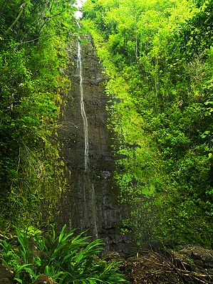
paradise found by PrestonSands The popular Manoa Falls Trail follows the Waihi Stream through a lush rainforest and bamboo thickets to a one-hundred-foot waterfall in the mountains above Honolulu. Although Manoa Falls is perennial, its flow varies with local rainfall, and it may only be a trickle during the dry season. Bring rain gear, and expect to get muddy! Hike From the parking lot at Treetops Restaurant, walk up Manoa Road to the signed start of the trail, located where the road switchbacks to the left to enter Lyon Arboretum. Passing through a gate at the trailhead, the trail leaves civilization behind, following an old road into a tropical rainforest. A little way in, the trail crosses Aihualama Stream in a small open area, where one gets a rare view of the surrounding ridges.
After one mile of hiking, the Manoa Falls Trail arrives at the bottom of Manoa Falls, in a narrow, steep-walled canyon, where it meets the Aihualama Trail. The falls emerge from the dense tree canopy above, sliding down a sheer wall of dark volcanic rock into the boulder-filled course of Waihi Stream, next to the trail. Apparently, a landslide occurred next to the falls in 2002, and Hawaiian authorities are paranoid of a future occurrence here, hence the warning signs and ropes near the falls forbidding hikers from leaving the trail. One can continue hiking on the Aihualama Trail, or return the way they came. Gate Policy: If a gate is closed upon arrival, leave it closed after you go through. If it is open, leave it open. Leaving a closed gate open may put cattle in danger. Closing an open gate may cut them off from water. Please be respectful, leave gates as found. The exception is signage on the gate directing you otherwise. Check out the Official Route and Triplogs. Leave No Trace and +Add a Triplog after your hike to support this local community. | ||||||||||||||||||||||||||||||||||||||||||||||||||||||||||||||||||||||||||||||||||