 Route Editor

| Guide | ♦ | 8 Triplogs | 0 Topics |
details | drive | no permit | forecast | route |
stats |
photos | triplogs | topics | location |
| 5 | 8 | 0 |
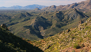
Follow the cow patties by JoelHazelton   The Hassayampa River Canyon Wilderness is one of several very remote BLM wilderness areas in Western AZ. Very little info is available for this area on the internet, but what I could find on the BLM website included "several miles of free-flowing Hassayampa river" and "extended backpacking trips". With the allure of perennial water and miles of remote trails, I've been considering this wilderness for a long time now. Fortunately, Christine Maxa recently released her book "Wickenburg Adventures", which describes several hikes in this wilderness, so I had a great opportunity to finally check it out. If you're interested in seldom-visited backcountry in Western Arizona, I highly recommend this book. The Hassayampa River Canyon Wilderness is one of several very remote BLM wilderness areas in Western AZ. Very little info is available for this area on the internet, but what I could find on the BLM website included "several miles of free-flowing Hassayampa river" and "extended backpacking trips". With the allure of perennial water and miles of remote trails, I've been considering this wilderness for a long time now. Fortunately, Christine Maxa recently released her book "Wickenburg Adventures", which describes several hikes in this wilderness, so I had a great opportunity to finally check it out. If you're interested in seldom-visited backcountry in Western Arizona, I highly recommend this book.Hike The trailhead for this hike is marked with a large cairn and a small wilderness boundary sign. There are immediately great views into the Hassayampa River Canyon and further on to the Southern Bradshaws. Hop on the trail and follow it up a small knoll and onto a ridge, which is the continuation of the ridge you were just driving on. The trail appears well-traveled (by cows, not people) and is very easy to follow. Soon it reaches an obvious junction with a large cairn. Bear right and continue deeper into the wilderness. As it descends the ridge to a saddle, the trail seems to split into a few different paths. Just follow the cairns to stay on the correct route. You will eventually reach the saddle with your first views of "The Needle" to your left. At the base of The Needle is the Hassayampa River, and the canyon you are peering down is your route. Continue past the saddle on the trail and it will make a sharp left and begin steep, loose switchbacks into the canyon. From here on out the trail is steep and slippery. You will likely be thinking about the return hike. Don't worry... It's not all bad coming back. The trail occasionally crosses the ravine but there are cairns to guide you wherever it gets confusing.
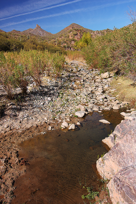
During the wet season, it may be worth it to forge on to the river. We decided to in November and were quite disappointed at the payoff, but it has also been a really dry year. Either way, if you came this far you might as well check it out. A couple of cairns guide you past the viewpoint and towards the trail. It's still a bit difficult to find the right path, though, since the ground has been trampled to bare rock by all the cows. Your best bet is to follow the cow patties. The trail follows the ridge to the river, and the closer you get the denser the cow evidence becomes. After about a half-mile the trail meets the floodplain and several cow paths will get you to the river. Choose the path of least resistance, which will likely require dipping beneath a couple of mesquites. Once at the creekbed, I would suggest building a small cairn at your entry point so you don't get lost on the way out. Kick it over when you return so as not to confuse future hikers. On this trip, we were greeted with a small pool full of minnows, deep enough to dip one's feet in. Most of the river was a slight trickle or dry. The riverbed is quite large with several channels that would likely be very beautiful with running water. Looking upstream are nice views of the Needle. Downstream are cliffs and cottonwood trees. We opted to follow the river downstream. More evidence of cows is passed, and the wilderness boundary comes quickly. Canyon walls seem to close in and box up farther downstream. I don't know the status of the land ownership, so I can't recommend any exploration past the wilderness boundary. When you've had your fill of the Hassayampa, return the way you came. Backpacking I'd love to backpack here during the spring. The river would be beautiful while flowing and the wildflower show would likely be spectacular during a good year. If you decide to overnight here, however, consider the cows first. This is the cows' area, and they've already marked every good campsite (and there are many of them along the river). If you camp near the river or along the lower half of the trail you will at least be smelling the cows all night, if not listening to them. Also, consider the cows if you want to filter water from the river. This stuff is seriously contaminated. Filtering/purifying *may* make it safe, but just the thought of what's going on not far upstream would probably deter me from drinking it. Check out the Official Route and Triplogs. Leave No Trace and +Add a Triplog after your hike to support this local community. | ||||||||||||||||||||||||||||||||||||||||||||||||||||||||||||||||||||||||||||||||||||||||||||


