 Route Editor

| Guide | ♦ | 52 Triplogs | 1 Topic |
details | drive | no permit | forecast | 🔥 route |
stats |
photos | triplogs | topic | location |
| 14 | 52 | 1 |
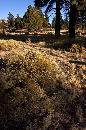
Not only green when summer's here... by hippiepunkpirate   Overview OverviewDon't get your hopes up, The Christmas Tree Trail on the eastern base of Mount Elden may not be quite deserving of its name. Yes, it winds through a forest dominated by ponderosa pines, but none of which would you want to use as decoration in your home during the holidays. I believe the trail gets its name from the nearby neighborhood bearing the same name, likely chosen by the developers to sound like a nice place to live. Hike The Christmas Tree Trail runs between Fat Man's Loop on the south and a junction with the Sandy Seep and Little Elden Trails on the north. If hiking from Fat Man's Loop, it is slightly uphill, but rolling through the drainages coming off Elden's west side. A couple of moderately steep slopes are encountered as the trail ascends the sides of these drainages, but these two sections are incredibly short (20-30 yards). As stated above, the trail stays within a forest predominantly of ponderosa pine. Some nice old growth is encountered, but younger "dog-hair" type growth is more common. Gamble Oak is also sprinkled in, along with some tall junipers that enjoy Elden's rain shadow. Dacite boulders evident of Elden's volcanic past also add a little interest here and there. Views of Elden's gnarled west face are fleeting, except for one large open area on the western edge of the trail where the City of Flagstaff has cleared an area and built a water tank just below the surface. Summer is undoubtedly the most beautiful time in this area when the grass is green, the weather is warm, wildflowers budding from the monsoons, and leaves decorate the oaks.
Suggested Usage Despite being an unlikely destination for out-of-town hikers, the Christmas Tree Trail does serve a purpose for those seeking a good hike. This purpose is as a connector trail. Many loops of varying lengths can be put together using the Mount Elden system of trails. There are quite a few loop options that can utilize Christmas Tree, especially if you decide to climb on a mountain bike (or horse, perhaps). With a long list of possibilities involving Christmas Tree, the one I would recommend is the Elden Lookout - Sunset - Heart - Christmas Tree Loop, with a length in the vicinity of 8 miles and AEG in the vicinity of 2,700 feet. I like it in that clockwise direction, getting all the major elevation done in a short steep fashion on the Elden Lookout Trail, allowing the hiker to enjoy the open views of the Sunset and Heart Trails in a nice moderately down-hill fashion. If you like a gradual ascent, so be it, but I think counterclockwise on this said loop is less enjoyable.
Check out the Official Route and Triplogs. Leave No Trace and +Add a Triplog after your hike to support this local community. One-Way Notice This hike is listed as One-Way. When hiking several trails on a single "hike", log it with a generic name that describes the hike. Then link the trails traveled, check out the example. | ||||||||||||||||||||||||||||||||||||||||||||||||||||||||||||||||||||||||||||||||||||||||||||||||||||||||||||||||||||||||||||||||||||||||||||||||||||||||||||||||||||||||||||||||||||||||||||||


