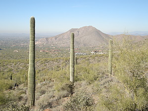
Overview: Great picnic hike! Inspiration point has a multitude of benches and seating rocks to hang out and eat a meal or snack! Fantastic at sunrise or sunset! Take a powerful headlamp if hiking at dawn or dusk! Watch for bikes as it's very popular with the experienced riders! Very dog friendly (doggy drinking fountain and pet waste station at trailhead)!
WARNING! Hiking and outdoor related sports can be dangerous. Be responsible and prepare for the trip. Study the area you are entering and plan accordingly. Dress for the current and unexpected weather changes. Take plenty of water. Never go alone. Make an itinerary with your plan(s), route(s), destination(s) and expected return time. Give your itinerary to trusted family and/or friends.
Permit $$
None
Directions
Road
To Gateway Trailhead Take the 101 to the Princess Drive/Pima Road exit. Go north on Pima Road to Union Hills Drive. Turn right (east) on Union Hills Drive to Thompson Peak Parkway. Turn right on Thompson Peak Parkway and head south about 1/2 mile to the Gateway Visitor Center on the left. There's plenty of parking and nice facilities here.
or
Take 101 to Bell Road exit (by way of either FLW Blvd exit 39 arriving from the south or Pima/Princess exit 36 arriving from the north). Go East on Bell road 1.7 miles and turn left onto Thompson Peak Parkway. The Gateway is 0.7 miles on the right. (18333 N. Thompson Peak Parkway)
From PHX (I-10 & AZ-51) - 28.4 mi, 36 mins From TUC (Jct 1-10 & Grant) - 126 mi, 2 hours 6 mins From FLG (Jct I-17 & I-40) - 141 mi, 2 hours 33 mins
 Route Editor

 Overview: Great picnic hike! Inspiration point has a multitude of benches and seating rocks to hang out and eat a meal or snack! Fantastic at sunrise or sunset! Take a powerful headlamp if hiking at dawn or dusk! Watch for bikes as it's very popular with the experienced riders! Very dog friendly (doggy drinking fountain and pet waste station at trailhead)!