Route Editor

| Guide | ♦ | 1 Triplog | 0 Topics |
details | drive | no permit | forecast | map |
stats |
photos | triplog | topics | location |
| 13 | 1 | 0 |
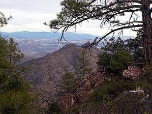
You've been warned by PrestonSands   Overview: Pinal Point, at 7242 feet, looms mightily above upper Chase Creek Canyon, in the mountains north of Morenci, Arizona. Judging from its location and prominence, one would guess that there is a great view to be had from Pinal Point. There is, but Pinal Point demands blood. Although the hike itself is short, one faces a savage bushwhack. Is the view worth the effort? That's for you to decide, but I'd say no. If you choose to attempt Pinal Point, bring a topo map and wear pants. Overview: Pinal Point, at 7242 feet, looms mightily above upper Chase Creek Canyon, in the mountains north of Morenci, Arizona. Judging from its location and prominence, one would guess that there is a great view to be had from Pinal Point. There is, but Pinal Point demands blood. Although the hike itself is short, one faces a savage bushwhack. Is the view worth the effort? That's for you to decide, but I'd say no. If you choose to attempt Pinal Point, bring a topo map and wear pants.Hike: From the Granville Campground trailhead, begin hiking up the Granville Trail #572, which departs from the highpoint of the campground loop road, near some cabins. The start of the trail is marked by a simple "trail" signpost, but no name is given. A few hundred yards up the Granville Trail, one passes through an opening in a barbed wire fence, where there is a second vertical brown signpost with the word "trail". There is a wooden sign nailed to a tree on your right identifying this as the junction with the Pinal Trail #713. Turn right to follow the Pinal Trail.
Leave the Pinal Trail at the saddle, and head uphill, to the southeast. Tangled thickets of thorny New Mexican locust and mountain mahogany clog every possible route through an already overcrowded woody disaster of pinyon pines, oak, juniper, and cane cholla. There is no route, so just accept the fact that you are going to be torn to pieces, and push through it toward Pinal Point. Once you reach the 7223' mesa, you can fight your way to the rocky southwestern edge of the mesa for a slightly less painful bushwhack. A few views of the peaks to the west may encourage you to keep going. Reaching the south edge of the mesa, Pinal Point again comes into view. With the enchanted forest and its eye gouging, skin ripping delights now behind, it's time to cross the narrow ridge connecting the 7223' mesa with Pinal Point. A nearly impenetrable, waist high hedge of manzanita, which at this point might seem downright pleasant, runs up to the summit of Pinal Point. Smash through it and conquer Pinal Point. The summit of Pinal Point indeed affords a 360 degree view of most of eastern central Arizona. A bewildering network of canyons, ridges, and peaks surround your vantage point. Two Forest Service boundary markers are the only signs of recent human visitation to this lonely perch. Enjoy Pinal Point. Hopefully, it was worth it. Check out the Triplog. Leave No Trace and +Add a Triplog after your hike to support this local community. | |||||||||||||||||||||||||||||||||||||||||||||||||||||||||||||||||||||||||||||||||||