Route Editor

| Guide | ♦ | 77 Triplogs | 0 Topics |
details | drive | permit | forecast | route |
stats |
photos | triplogs | topics | location |
| 344 | 77 | 0 |
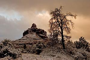
short climb up stable redrock by MtnGeek  Bell Rock is one of the major landmarks in Sedona overlooking Oak Creek Village. The climb is a fun short climb. You have to use your hands to climb up many small 5-foot cliffs at the bottom of it. You gain about 5 feet elevation, then walk on level ground for 20 feet, then do it all over again. You want to aim yourself in the crevasse facing the road. Bell Rock is one of the major landmarks in Sedona overlooking Oak Creek Village. The climb is a fun short climb. You have to use your hands to climb up many small 5-foot cliffs at the bottom of it. You gain about 5 feet elevation, then walk on level ground for 20 feet, then do it all over again. You want to aim yourself in the crevasse facing the road.After a while, you will be walking on steep solid rock. You may need to use your hands for balance sometimes. Watch out for pebbles flying past you. Once you reach the end of the crevasse, cliffs will surround you. There are two ways from the top from here. You can go left and walk up through a tiny crevasse. When you get to the end, you will need to wedge your body up in the cliffs facing each other to climb straight up. If this does not appeal to you, you can take the right approach. This is easier. There are many handholds and footholds; searching for them and testing them is easy. This route is about at a 65 degrees angle. Once on top of the ridge, there are three smaller points you can climb up. Each of them is an easy ascent. Then there is the 50-foot spire, 90 degrees angle. You will need ropes if you want to finish the climb. It looks easy going up, but coming down would be difficult.
Bell Rock is a great climb. I would recommend it to anybody that likes a little adventure. Standing on the top is wondrous. You are looking down cliffs in every direction. You can see where people took a wrong turn and ended up on a lower pinnacle and can't get any higher. Very few people make it to the very top.
Check out the Official Route and Triplogs. Leave No Trace and +Add a Triplog after your hike to support this local community. | ||||||||||||||||||||||||||||||||||||||||||||||||||||||||||||||||||||||||||||||||||||||||||||||||||||||||||||||||||||||||||||||||||||||||||||||||||||||||||||||||||||||||||||||||||||||||||||||||||||||