Towel Creek Ruins - West Access, AZ | HikeArizona
username
X
password
register
for free!
help
   This is likely a great time to hike this trail!  Check out "Preferred" months below, keep in mind this is an estimate.
   🔥

Towel Creek Ruins - West Access, AZ

Guide 17 Triplogs  0 Topics
  3.5 of 5 
Fav
Wish
16
details
drive
permit
forecast
🔥
route  
stats
photos
triplogs
topics
location
91 17 0
HAZ reminds you to respect the ruins. Please read the Archaeological Resources Protection Act of 1979 & Ruins Etiquette
Statistics
tap icons for details
Difficulty 2 of 5
Route Finding 2 of 5
Distance Round Trip 6.08 miles
Trailhead Elevation 2,977 feet
Elevation Gain 542 feet
Accumulated Gain 712 feet
Avg Time Round Trip 3 - 4 hours
Kokopelli Seeds 9.64
 Interest Ruins & Perennial Creek
 Backpack Yes
feature photo
Photos Viewed All MineFollowing
Will recalculate on button tap!
14  2021-04-23 AugustWest
11  2017-05-01 survivordude
13  2016-03-05 FOTG
13  2013-01-04
Gap Creek to Verde River
fotogirl53
7  2011-01-10 hippiepunkpirate
12  2009-10-19 scottfyfe
7  2005-12-14 cyn
4  2002-12-04 T150
Page 1,  2
Author
author avatar Guides 8
Routes 0
Photos 114
Trips 14 map ( 68 miles )
Age Female Gender
Location Scottsdale, AZ
Associated Areas
list map done
Camp Verde Region
Historical Weather
Trailhead Forecast
Radar Map
Expand Map
Preferred Nov, Feb, Mar, Jan → 10 AM
Seasons   Late Spring to Late Autumn
Sun  6:55am - 6:24pm
Official Route
 
0 Alternative
 
 Water
Historic Fire Perimeteracres
🔥 2021 Backbone Fire114.9 mi**


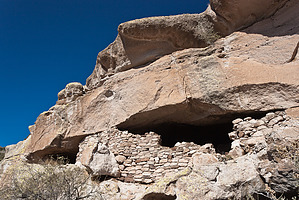
Holly Guano Methane Batman!
by Desertboots

   Likely In-Season!
I questioned the wisdom of posting this trail as when I hiked it I thought I was in the wrong place. As it turns out I was in exactly the right place.


This trail can be accessed from two different places. You can reach a trailhead off Fossil Springs Road and make it a 14-mile hike, or you can reach the trailhead via Gap Creek trail from Camp Verde. We chose Camp Verde as that makes it a fairly easy 6-mile out and back trail.

The area is beautiful, lush, and fairly easy to get to. We started on a nice sunny and windy morning from Phoenix and drove up to Camp Verde. The driving directions I've included are exact. From the parking area at the D-Tail ranch, you follow the Gap Creek Trail down to the Verde River. You haven't reached the Towel Creek trail, but if you look across the Verde at a confluence between two red cliffs and the draw that cuts between them, that's Towel Creek. To reach the actual trail #67, you have to bushwhack a bit upstream, then cross the Verde. It's not hard to do, and we didn't cross the river just yet. We walked roughly a half-mile upstream first. If you can find a place to ford the river, do so at any time. The coordinates for where the trailhead is roughly 33 35.81N 112 14.86W. This reading was taken while standing across the river from the trailhead. The Verde is deep in places along here and so we just walked upstream till we found a place to cross, then walked back downstream to the trailhead. A cairn marks it. The trail goes straight up to a fence line. You then follow the fence line to a gate. Go through the gate and follow the Cairns and the beaten path. Sometimes the trail is hard to find but as long as you look for Cairns, you'll be okay.


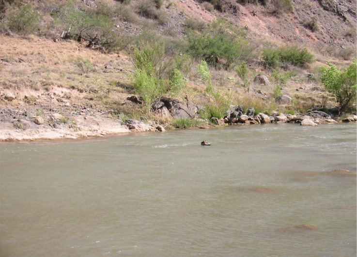
After about 2.5 miles the trail dips down to Towel Creek. Follow the creek in lieu of a trail. I only went a little way before I tripped and fell and hurt my knee. My hiking companion went a little further and found an old cowboy shack. From here, there is no trail to the ruins and I determined we were still half a mile from the ruins. The GPS coordinates for the ruins are 34 24.45N 111 45.16W. We were about .45 miles from the ruins at the Cowboy shed. We never did find them.

Follow the same trail back. When you cross the Verde, it's a good idea to have Tevas or something to cross in, as the bottom is rocky. My hiking partner didn't tie her shoes tight enough to her pack and so they ker-plunked into the river, but floated downstream aways and came to rest on the shore where we retrieved them. That was lucky.


If you chose this trail, let me know if you ever find the ruins. Then you can take me there!

Check out the Official Route and Triplogs.

Gate Policy: If a gate is closed upon arrival, leave it closed after you go through. If it is open, leave it open. Leaving a closed gate open may put cattle in danger. Closing an open gate may cut them off from water. Please be respectful, leave gates as found.

Leave No Trace and +Add a Triplog after your hike to support this local community.

2002-05-20 Desertboots
    WARNING! Hiking and outdoor related sports can be dangerous. Be responsible and prepare for the trip. Study the area you are entering and plan accordingly. Dress for the current and unexpected weather changes. Take plenty of water. Never go alone. Make an itinerary with your plan(s), route(s), destination(s) and expected return time. Give your itinerary to trusted family and/or friends.

     Permit $$
    None

    Prescott Forest
    Prescott National Forest Pass

    Only trailheads with six "amenities" have fees. Amenities are picnic tables, trash, toilet, parking, interpretive signing and security.


     Directions
    or
    or
     Road
    High Clearance possible when dry

    To hike
    From Camp Verde, follow 260 to Salt Mine Road and head west. Salt Mine Road just north of the Verde River crossing. The road eventually curves south and turns into a gravel road. I would say a passenger car would be okay, but at least high clearance would be ideal. At about 3 miles, the main dirt road turns left toward Beasley Flat and the Verde River. Do not go to Beasly Flat. Keep driving straight on FR 574, which gets narrower and rougher. You'll cross Gap Creek after about 8 miles and then you'll reach the D-Tail Ranch. On the USGS quad for Horner Mountain, the ranch is called Brown Springs Ranch. That was circa 1967. That topo also features the trail and is a good reference. Park at the D-Tail Ranch, there is a little parking area and some trail signs.
    helpcorrectionissue

    end of page marker