 Route Editor

| Guide | ♦ | 16 Triplogs | 0 Topics |
details | drive | no permit | forecast | 🔥 route |
stats |
photos | triplogs | topics | location |
| 51 | 16 | 0 |
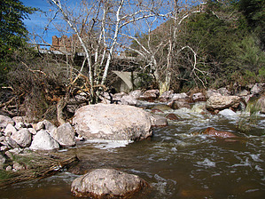
  Overview OverviewShort and scenic segment of the historic US Highway 70. The original bridge was in service from 1900-1949 and is still completely intact. Construction was concrete and steel and the design was a filled spandrel arch.
Check out the Official Route and Triplogs. Leave No Trace and +Add a Triplog after your hike to support this local community. One-Way Notice This hike is listed as One-Way. When hiking several trails on a single "hike", log it with a generic name that describes the hike. Then link the trails traveled, check out the example. | |||||||||||||||||||||||||||||||||||||||||||||||||||||||||||||||||||||||||||||||||||||||


