To hikeFrom Globe (junction at US60), drive southeast along US70 approximately 24.2 miles to SC-8. SC-8 to Point of Pines is a paved highway. There are NO services of any kind at Point of Pines. Drive northeast along SC-8 approximately 15 miles to SC-5. The remainder of the drive to Wooden Crossing is gravel/dirt. If it is raining, be prepared for horrendous mud.
Drive northwest along SC-5 for approximately 7.8 miles to SC-7. Drive northeast along SC-7 for approximately 8.7 miles to SC-4. SC-4 is a main reservation artery coming across from US60 to US191 and goes through Point of Pines.
Drive east/southeast along SC-4 for approximately 3.3 miles to SC-1505. The remaining miles to Wooden Crossing are on un-maintained 4x4 roads. Drive north for approximately 1.2 miles along SC-1505 to Round Valley Tank. Continue past Round Valley Tank for approximately 1.2 miles to a right turn, which is SC-1504. SC-1505 will bend northwest prior to reaching the turn. Drive north/northeast along SC-1504 for approximately 3.0 miles down to the river at Wooden Crossing. SC-1504 is very rugged along the last mile heading down to the river. Most stock 4x4 vehicles with LT rated tires are sufficient for reaching this location. Wooden Crossing is not a "crossing" and the location is only noted on reservation maps. SC-1505 and SC-1504 are not noted on USGS topo maps. See attached topos maps for clarification of these roads.
!!WARNING!! Wooden Crossing is an extremely remote location. The nearest cell phone signal is almost 40 miles away. Use caution and discretion during ALL activities. You're on your own!
 Route Editor


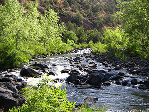
 Overview: Stunningly beautiful and rugged segment of the Black River, within the San Carlos Indian Reservation. Activities consist of camping, fishing, and hiking. !!WARNING!! Hiking this particular river segment is demanding and strenuous with an undefined trail. Recommended route is downstream.