Route Editor

| Guide | ♦ | 1 Triplog | 0 Topics |
details | drive | permit | forecast | map |
stats |
photos | triplog | topics | location |
| 2 | 1 | 0 |
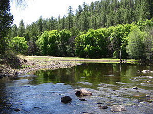
big bad river by HAZ_Hikebot   A beautiful segment of the Black River, within the San Carlos Indian Reservation. Activities consist of camping, fishing, and hiking. Hiking this particular river segment is easy to moderate with a defined trail both upstream and downstream. The camping/parking area is located above the river with moderate shade from ponderosa pine, oak, and juniper. Access to the river follows an obvious trail with a descent of 400 vertical feet. A beautiful segment of the Black River, within the San Carlos Indian Reservation. Activities consist of camping, fishing, and hiking. Hiking this particular river segment is easy to moderate with a defined trail both upstream and downstream. The camping/parking area is located above the river with moderate shade from ponderosa pine, oak, and juniper. Access to the river follows an obvious trail with a descent of 400 vertical feet.33° 30' 23.10" N, 109° 49' 24.13" W
Check out the Triplog. Leave No Trace and +Add a Triplog after your hike to support this local community. | ||||||||||||||||||||||||||||||||||||||||||||||||||||||||||